Ufsar Dam
Iceland /
Austurland /
Hofn /
World
/ Iceland
/ Austurland
/ Hofn
dam
Add category
Part of Kárahnjúkar Hydropower Plant.
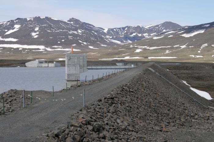
Ufsar Dam is a rockfill and gravel dam with a central core of glacial moraine. The dam is 38 m high and 620 m long. Fill volume is 0.5 million cubic meters.
The Ufsarlon intake pond is 1 square kilometer in area.
Keldua Tunnel, 1.9 km long, on the east side of the intake pond conveys water from the Keldua reservoir. On the east side of Keldua reservoir, the Grjota Tunnel, 1.7 km long, conveys water from the Gjota river.
Wikipedia article: http://en.wikipedia.org/wiki/Kárahnjúkar_Hydropower_Plant
Nearby cities:
Coordinates: 64°49'30"N 15°24'4"W
- Keldua Dam 3.9 km
- Desjarárstífla Dam 22 km
- Spillway 23 km
- Kárahnjúkastífla Dam 24 km
- Blönduvirkjun dam 207 km
- Árbæjarstífla 318 km
- Glascarnoch Dam 973 km
- Laggan Dam 1054 km
- Treig Dam 1057 km
- Cruachan Dam 1090 km
- Ufsarlón 0.8 km
- Kelduárlón Reservoir 5.4 km
- Karahnjukar Hydropower Plant Headrace Tunnel 11 km
- Gripdeild 43 km
- Reyðarfjörður 61 km
- Sandvatn 63 km
- Fjarðaál Aluminum Smelter 65 km
- Lagarfljót 69 km
- Urriðavatn 70 km
- Reyðarfjörður 72 km