Fimmvörðuháls
Iceland /
Sudurland /
Vik i Myrdal /
World
/ Iceland
/ Sudurland
/ Vik i Myrdal
World / Iceland / Suðurland
hut, mountain pass


Fimmvörðuháls is the area between the glaciers Eyjafjallajökull and Mýrdalsjökull in southern Iceland.
The route between Skógar and Thórsmörk goes through this pass and is one of the most popular walking routes in Iceland, despite being 22km long and involving 1000m of climbing.
At Fimmvörðuháls there is a modern comfortable mountain hut owned by Útivist, one of the Icelandic hiking associations. Also nearby there is an older, less equipped hut called Baldvinsskáli. The route from Skógar is particularly beautiful as numerous waterfalls are passed along the way. The route is only accessible between mid-June and late-August. At the night of 16 May 1970, three travellers died passing the mountain pass in a snowstorm.
It is also possible to combine the Fimmvörðuháls route with the Laugavegur trek between Landmannalaugar and Thórsmörk to make a trip of 4-6 days in length.
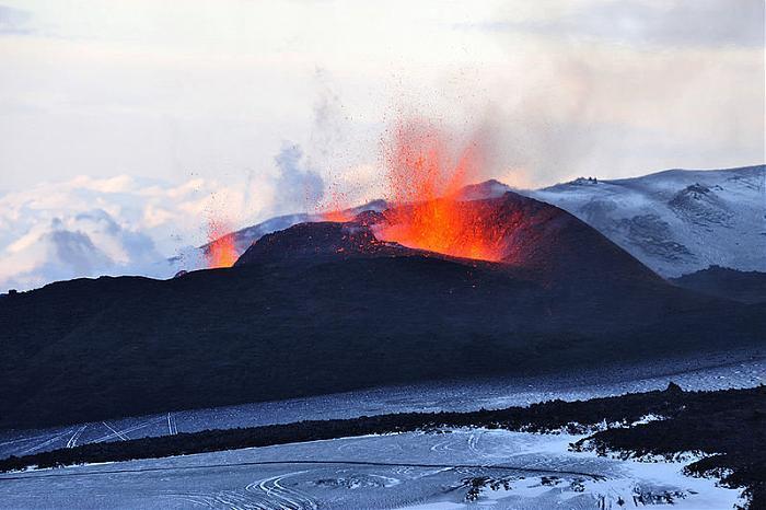
On March 20th, 2010 an eruption of the Eyjafjallajökull volcano began in Fimmvörðuháls following months of small earthquakes under the Eyjafjallajökull glacier. The eruption began around 23:00 PM and opened a 0.5 km (0.3 mi) long fissure on the northern part of the pass. Just over a week later, the Fimmvörðuháls eruption produced a 300-meter-long fissure and new craters were seen erupting on a north trending path toward the area of Thórsmörk, a popular tourist nature preserve, prompting tours to briefly stop as volcanologists assessed the situation further.
This has been followed in April by a larger eruption on Eyjafjallajökull itself, and there are fears that this will trigger a much bigger eruption of nearby Katla.
The route between Skógar and Thórsmörk goes through this pass and is one of the most popular walking routes in Iceland, despite being 22km long and involving 1000m of climbing.
At Fimmvörðuháls there is a modern comfortable mountain hut owned by Útivist, one of the Icelandic hiking associations. Also nearby there is an older, less equipped hut called Baldvinsskáli. The route from Skógar is particularly beautiful as numerous waterfalls are passed along the way. The route is only accessible between mid-June and late-August. At the night of 16 May 1970, three travellers died passing the mountain pass in a snowstorm.
It is also possible to combine the Fimmvörðuháls route with the Laugavegur trek between Landmannalaugar and Thórsmörk to make a trip of 4-6 days in length.
On March 20th, 2010 an eruption of the Eyjafjallajökull volcano began in Fimmvörðuháls following months of small earthquakes under the Eyjafjallajökull glacier. The eruption began around 23:00 PM and opened a 0.5 km (0.3 mi) long fissure on the northern part of the pass. Just over a week later, the Fimmvörðuháls eruption produced a 300-meter-long fissure and new craters were seen erupting on a north trending path toward the area of Thórsmörk, a popular tourist nature preserve, prompting tours to briefly stop as volcanologists assessed the situation further.
This has been followed in April by a larger eruption on Eyjafjallajökull itself, and there are fears that this will trigger a much bigger eruption of nearby Katla.
Wikipedia article: http://en.wikipedia.org/wiki/Fimmvörðuháls
Nearby cities:
Coordinates: 63°37'22"N 19°26'25"W
- Skagfjörðsskáli (Þórsmörk) 7.7 km
- Emstrur 16 km
- Álftavatn 28 km
- Landmannalaugar 45 km
- Hut Site (Ancient) 1237 km
- Hut Circles and Enclosure 1695 km
- Paloma 3435 km
- AMC Zealand Hut 3882 km
- Quanset Hut 4111 km
- Mount Tahoma Trails (south district) 6028 km
- Eyjafjallajökull 9 km
- Mýrdalsjökull 18 km
- Katla 19 km
- Tindfjallajökull 21 km
- Hekla 43 km
- Mýrdalssandur 43 km
- Álftaversgígar Nature Reserve 48 km
- Sigöldulón 63 km
- Laki 78 km
- Langisjór 82 km
Comments