former RAF Llanbedr
United Kingdom /
Wales /
Barmouth /
World
/ United Kingdom
/ Wales
/ Barmouth
World / United Kingdom / Wales
research, RAF - Royal Air Force, closed / former military
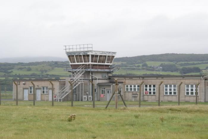
Llanbedr Airfield (ICAO: EGOD), formerly RAF Llanbedr, is a former military facility located in the Snowdonia National Park near the village of Llanbedr, Gwynedd, northwest Wales. It opened in 1941 as part of RAF Fighter Command's 12 Group. After the war it served as a maritime bombing & missile range evaluation base of operations and later still for the research, development, testing & evaluation of a variety of aerospace weapons technologies.
In the intervening years Llanbedr has changed its name often (if not its identity & function so much), per RAF Llanbedr until 1957, RAE Llanbedr(Royal Aircraft Establishment) until 1992, T&EE Llanbedr (Testing & Evaluation Establishment)until 1995, DERA Llanbedr until 2001, when most of DERA became QinetiQ.
In December 2008, the Welsh Assembly Government gave the go-head for the current operators of the former RAF Kemble airfield near Cirencester to take over this airfield, subject to Kemble obtaining the "relevant permissions and consents." In November 2009, the Snowdonia National Park Authority took external legal advice and refused to issue certificates of lawful use to Kemble. In August 2011, a certificate was granted to Llanbedr Airfield Estates for use of the airport to test and develop unmanned aerial vehicles.
www.swatt.org/airfield.html
Wikipedia article: http://en.wikipedia.org/wiki/RAF_Llanbedr
Nearby cities:
Coordinates: 52°48'22"N 4°7'31"W
- Former RAF Upper Heyford 216 km
- Kendrew Barracks (former RAF Cottesmore) 233 km
- Former RAF Elvington 242 km
- Former RAE Bedford /RAF Thurleigh 254 km
- Alconbury Developments Limited (Former RAF Alconbury) 266 km
- Former RAF Binbrook 271 km
- Former tank training ground 296 km
- Holy Loch 360 km
- Terrain Militaire de Souges 913 km
- 120 Airbase Cazaux 941 km
- Shell Island 0.8 km
- Royal St. David's Golf Club 6.1 km
- Y Llethr 9 km
- Barmouth 10 km
- Black Rock Sands 12 km
- Gamlan River Valley 13 km
- Llyn Trawsfynydd 17 km
- Coed-y-Brenin 17 km
- Parc Cenedlaethol Eryri (Snowdonia National Park) 20 km
- Mach Loop 26 km