Shibchar Upazila HQ
Bangladesh /
Faridpur /
Char Bhadrasan /
রর
World
/ Bangladesh
/ Faridpur
/ Char Bhadrasan
World / Bangladesh / Dhaka / Faridpur / Madaripur
city
Add category
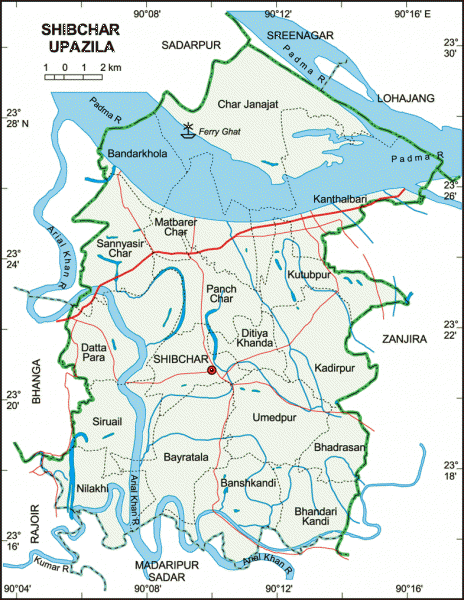
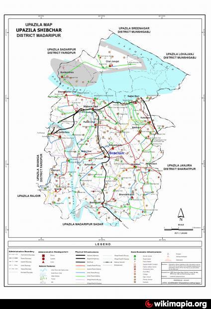
Shibchar Upazila (Madaripur district) with an area of 321.88 sq km, is bounded by Lohajang, Sreenagar and Sadarpur upazilas on the north, Rajoir and Madaripur sadar upazilas on the south, Zanjira upazila on the east, Bhanga upazila on the west. Main rivers are Padma, Arial Khan and Mainakata; depressions 12, noted of which are Padma Beel, Mirzar Char Beel, Hashemdi Beel and Keshabpur Beel.
Shibchar town is located at 23.341999N 90.1708708E. Shibchar (Town) consists of 9 wards and 14 mahallas. The area of the town is 11.2 sq km. It has a population of 20201; male 50.12%, female 48.88%; density of population is 1804 per sq km. Literacy rate among the town people is 43.5%.
Shibchar thana was established in 1930 and was turn into an upazila in 1983. It consists of 18 union parishads, 467 villages and 108 mouzas.
As of the 1991 Bangladesh census: Population 306082; male 51.46%, female 48.54%; Muslim 95.32%, Hindu 4.12%, others 0.56%.
Religion institutions: Mosque 1256, temple 25, mausoleum 1.
Literacy and educational institutions: Average literary 29.6%; male 34.1%, female 19.4%. Educational institutions: college 4, high school 25, junior high school 6, government primary school 118, non-government primary school 57, satellite school 2, community school 11, madrasa 79. Noted educational institutions: Barhamganj Government College (1964), Nandakumar Institution (1910), Bahadurpur Shariatia Alia Madrasa, Dattapara TN Academy, Bharashan GC Academy, Bhandarikandi AM High School, Panchcr High School, Takerhat High School, Utrail High School, Khankandi Syed Ashraf Ali High School, Utrail High School, etc.
Cultural organisations: Rural club 28, officers' club 1, press club 1, public library 1, Shilpakala Academy 1, cinema hall 4, auditorium 1, community centre 15, co operative society 212.
Main occupations: Agriculture 47.74%, agricultural labourer 23.98%, wage labourer 2.49%, commerce 9.33%, transport 1.3%, service 3.94%, others 11.22%.
Land use: Total cultivable land 23963 hectares, fallow land 100 hectares; single crop 28.97%, double crop 66.55% and triple crop land 4.48%.
Land control: Among the peasants, 34% are landless, 28% small, 22% intermediate and 16% rich; cultivable land per head 0.085 hectare.
Fisheries, dairies and poultries Dairy 17, poultry 64, artificial cattle breeding centre 1.
Communication facilities- Roads: pucca 47.37 km, semi pucca 47.50 km and mud road 340 km.
Manufactories: 42 including rice mill, flour mill, oil mill, bakery, welding and sawmill.
Cottage industries: Weaving, goldsmith, blacksmith, potteries, bamboo & cane work and tailoring.
NGO activities: Operationally important NGOs are asa, Care, brac, Christian Aid, Gana Unnayan Prachesta, Janasahajug Sangstha (Goatala).
Health centres: Upazila health complex 1, family welfare centre 9, satellite clinic 3, veterinary hospital 1.
Nearby cities:
Coordinates: 23°20'44"N 90°10'11"E
- Bara Gopalpur Union 8.9 km
- Cirnodi 11 km
- Jazirah Union 16 km
- Madaripur 18 km
- Bhanga Upazila HQ 20 km
- Sadarpur Upazila HQ 21 km
- Lohajang Upazila 23 km
- Arial Beel Area 26 km
- Dhaka Division 90 km
- TROPIC OF CANCER 949 km
Comments