(Original) Palm Springs Municipal Airport (site) (Palm Springs, California)
USA /
California /
Palm Springs /
Palm Springs, California
World
/ USA
/ California
/ Palm Springs
World / United States / California
invisible, draw only border, historical layer / disappeared object
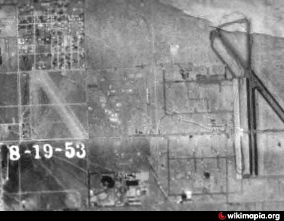
The date of construction for the original Municipal Airport for the town of Palm Springs has not been determined.
The earliest depiction of the Palm Springs Airport which has been located was on the 1929 "Rand McNally Standard Map of CA With Air Trails".
It described the Palm Springs "Stevens Airport" as being operated by W. Seaton, and measuring 2,500' x 300' in size.
The 1944 US Army/Navy Directory of Airfields described the original Palm Springs Airport as having a 3,200' unpaved runway.
The original airport was abandoned as of May 23, 1946, according to a June 1946 Department of Commerce Airman's Guide.
members.tripod.com/airfields_freeman/CA/Airfields_CA_Ri...
Nearby cities:
Coordinates: 33°49'23"N 116°32'6"W
- Minerva Road 6.8 km
- PCT crossing at underpass of I-10 19 km
- Coachella Valley 22 km
- Saw Mill Trail 29 km
- Epicenter of m3 quake 34 km
- Yucca Bowl 37 km
- epicenter of m2.6 quake 40 km
- Canal Tunnel 93 km
- Canal Tunnel 93 km
- epicenter of m2.7 quake 113 km
- Sunrise Park 1.2 km
- Ruth Hardy Park 1.6 km
- Palm Springs International Airport (PSP/KPSP) 2.7 km
- Smoke Tree Ranch 3.3 km
- Escena Golf Club 3.6 km
- Araby 3.6 km
- Palm Springs Country Club 4.1 km
- Desert Princess Country Club 4.8 km
- Panorama Park 6.5 km
- San Andreas Fault Zone (appr.) 35 km