Fish Creek Falls
USA /
California /
Santa Clarita /
World
/ USA
/ California
/ Santa Clarita
World / United States / California
water
Add category
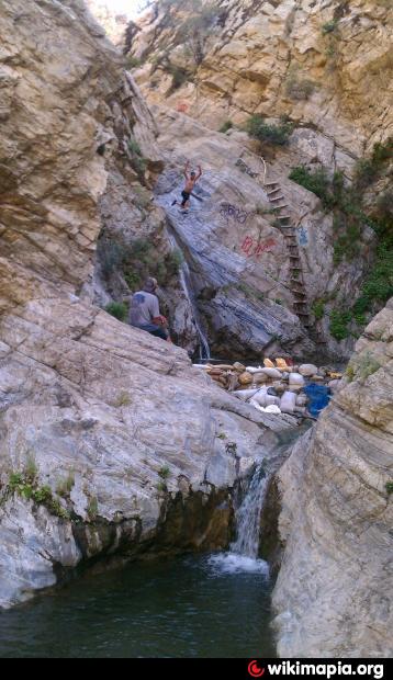
Located on Fish Creek in the Sierras South west of the village of Lake Hughes consists of a series of cascades that together drop about 50 feet from 2,700 ft to 2,650 ft (estimated elevations). Getting to the falls: Start from an unmarked pullout on Lake Hughes Road 9.7 km (6.0 miles) south of Lake Hughes where Fish Creek crosses the road. Follow Fish Creek for 1.3 km (0.8 miles) to the base of the falls.
Note that it is impossible to make the trek without getting wet if there is water flowing in the creek so dress appropriately.
Unfortunately use of this area has resulted in damage from graffiti and trash left behind by uncaring visitors.
Note that it is impossible to make the trek without getting wet if there is water flowing in the creek so dress appropriately.
Unfortunately use of this area has resulted in damage from graffiti and trash left behind by uncaring visitors.
Nearby cities:
Coordinates: 34°38'55"N 118°31'20"W
- Castaic Lake 14 km
- Pyramid Lake 26 km
- Lake Casitas 82 km
- Lake Isabella 120 km
- Lake Cachuma 134 km
- Soda Lake 144 km
- Lake Success 165 km
- Tulare Lake 182 km
- Lake Kaweah 202 km
- Morro Bay 229 km
- San Andreas Fault (Zone) 1.2 km
- George R. Bones Wildlife Sanctuary (aka Desert Pines Wildlife Sanctuary) 11 km
- Arthur B. Ripley Desert Woodland State Park 12 km
- Garland Solar Project 20 km
- Solar Farm 21 km
- Pyramid Lake 24 km
- National Cement Company 30 km
- Hungry Valley State Vehicular Recreation Area 32 km
- Tehachapi Tunnel 35 km
- Los Padres National Forest 117 km
San Andreas Fault (Zone)
George R. Bones Wildlife Sanctuary (aka Desert Pines Wildlife Sanctuary)
Arthur B. Ripley Desert Woodland State Park
Garland Solar Project
Solar Farm
Pyramid Lake
National Cement Company
Hungry Valley State Vehicular Recreation Area
Tehachapi Tunnel
Los Padres National Forest
Comments