Pyramid Lake
USA /
California /
Lebec /
World
/ USA
/ California
/ Lebec
World / United States / California
reservoir lake
Add category
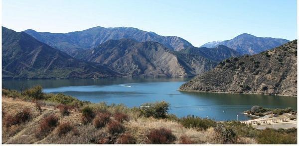
Artificial reservoir, completed 1973. Fed by Piru Creek and the waters of the California Aqueduct. Lies on top of pre-interstate 5 highway 99. Named Pyramid for the Large Pyramid-shaped rock at the foot of the dam. ("Pyramid Rock"). Provides hydroelectric power and flood regulation via underground tunnels connecting Pyramid lake to Castaic lake to the southwest.
Wikipedia article: http://en.wikipedia.org/wiki/Pyramid_Lake_(Los_Angeles_County,_California)
Nearby cities:
Coordinates: 34°39'53"N 118°46'55"W
- Elderberry Forebay 14 km
- Castaic Lake 17 km
- Lake Piru 19 km
- Lake Casitas 60 km
- Lake Cachuma 110 km
- Lake Isabella 120 km
- Twitchell Reservoir 148 km
- Lopez Lake 168 km
- Santa Margarita Reservoir 173 km
- Lake Kaweah 197 km
- Hungry Valley State Vehicular Recreation Area 11 km
- National Cement Company 19 km
- Tehachapi Tunnel 25 km
- San Andreas Fault (Zone) 25 km
- Arthur B. Ripley Desert Woodland State Park 28 km
- George R. Bones Wildlife Sanctuary (aka Desert Pines Wildlife Sanctuary) 28 km
- Garland Solar Project 30 km
- Solar Farm 35 km
- Los Angeles County, California 63 km
- Los Padres National Forest 94 km
Hungry Valley State Vehicular Recreation Area
National Cement Company
Tehachapi Tunnel
San Andreas Fault (Zone)
Arthur B. Ripley Desert Woodland State Park
George R. Bones Wildlife Sanctuary (aka Desert Pines Wildlife Sanctuary)
Garland Solar Project
Solar Farm
Los Angeles County, California
Los Padres National Forest