Triangle Park (Quezon City)
Philippines /
Southern Tagalog /
Malanday /
Quezon City
World
/ Philippines
/ Southern Tagalog
/ Malanday
World / Philippines / Metropolitan Manila / Quezon City
downtown / central business district, draw only border


Triangle Park is the envisioned "master planned" Central Business District of Quezon City. It shall become a
"... world-class, highly transit-oriented, mixed-use community that is walkable, vibrant night and day, with easy access to amenities that make urban living comfortable, convenient and environmentally compliant..."
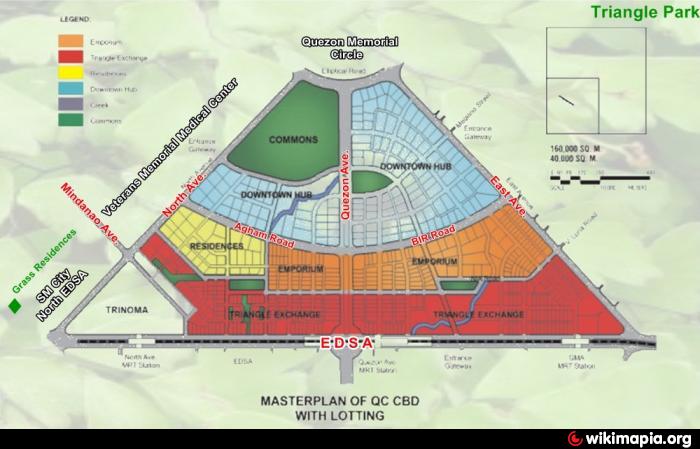
The development sprawls OVER, more than 250 hectares, in a strategic location right in the heart of Metro Manila. It covers properties within the NORTH and EAST TRIANGLES and the VETERANS MEMORIAL area, which have been chosen to become a model, mixed-use development that shall play a critical role not only in Metro Manila, but also internationally.
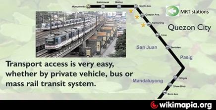
The QC-CBD, called Triangle Park, has one of the most ideal locations, in terms of metropolitan access, with the use of at least 3 mass transit stations, and with a frontage on the main thoroughfare in Metro Manila that is longer than any of the existing major Central Business Districts.
It is a landmark recreational area, distinct for having two large parks within and nearby, the Ninoy Aquino Parks and Wildlife and the Quezon Memorial Circle. It shall be an environmentally compliant CBD, promoting green architecture, and minimal carbon-emitting transport modes.
A well-planned transit loop shall run within Triangle Park, with park-lined boulevards, to promote accessibility of even inner-most properties, promoting greater social contact, while contributing to increasing land values throughout the CBD.
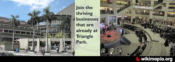
Triangle Park is most attractive for retail and wholesale businesses that can take advantage of the direct link to transport lines. It will also be an attractive area as incubator or nurturer of companies and people venturing into the new economy/ digital marketplace. It is a lifestyle and business area packaged into an integrated whole. Very convenient are the hospitals and medical services facilities already available and being enhanced within and proximate to the QC-CBD area.
International institutions agree on the area's large economic potential. It is one of the few remaining parcels of land that are strategically located, easily accessible from all directions, and ripe for development designed to enhance asset value, as well as showcase a model urban environment.
This new Triangle Park will form the core of high-quality businesses and a mix of support, residential and other activities that would build on the existing retail cluster, good access and internal circulation system, transit depot, information technology(IT)-friendly environment as well as residential communities and government facilities in the vicinity.
Triangle Park is masterplanned to have mixed-use development oriented towards transit facilities. It is directly accessible to current and planned mass rail transit stations and bus routes. The urban design plan directly connects Triangle Park entrances and gateways to transit hubs. Internal circulation will also support easy access to all parts of the CBD by walking, biking or riding. People will be provided several transport and movement options.This minimizes travel to work, avoids congestion experienced in other CBDs, creates greater opportunities for social contact, urban vitality and safer places, achieves better energy efficiency and efficient use of spaces and buildings, and increases efficiency of urban facilities.
The Triangle Park's comprehensive masterplan for the East and North Triangles provides the guidelines and standards necessary to stimulate the development of a well-organized CBD that is able to maximize land values, promote quality living, while adhering to globally acceptable standards of environment-friendly communities.
The development guidelines have organized the CBD into five districts: Triangle Exchange, Emporium, Downtown Hub, Residences, and Commons, and with very clear delineations of sub-districts. All are mixed-use, but each with a clear predominant use.
Premium has been placed on design principles of urban efficiency, diversity, accessibility, security and increased pedestrianization. Open spaces will be given prime importance with the development of several linear parks, parkways lining roads, pocket parks along water systems, building plazas and district parks, in addition to the existing large parks in the area, Ninoy Aquino Parks and Wildlife and the Quezon Memorial Circle.
Among the upcoming developments is Vertis North, Ayala Land Inc. (ALI) and the National Housing Authority's joint venture project to develop a 29.1 hectare North Triangle property. ALI's other investment is the shopping mall, Trinoma. Eton Properties has been developing Centris, while SM has expanded its developments on the opposite side of North AvenueThe Triangle Park's five major districts are mixed use, anchored on major uses – mixed use with retail on ground floor, transit oriented mixed use, mixed-use commercial, mixed-use residential, mixed use institutional and commercial.
Mixed uses with ground floor retail will be located along the main Park Lane roads that loop around Triangle Park. Comprising the largest portion (20%) of total built space, these can be commercial/office/residential/institutional maximizing ground floor retail. This is followed by Mixed-use Commercial with 19% which is hinged upon office uses. Mixed-use Institutional sprawling over 13% of the area, is essentially institutional or related to the administration of government, the Triangle Park area being originally envisioned to be the National Government Center.
Mixed-use Transit Development will cover 3% of the area. These are compact developments built around the GMA-Kamuning and Quezon Avenue MRT Stations. They have higher densities, walkable scale, and a mix of uses including residential, retail, office, institutional and commercial. Mixed Use Residential (2%) will have predominantly residential land use, with commercial amenities to serve its residents.
Densities will range from a low FAR I in the Commons District to a high FAR 16 in the urban core of the Triangle Exchange District. Densities are highest along the EDSA corridor and diminish towards the Quezon Memorial Circle.
The building density feature is deliberate. Higher densities along EDS will in effect establish a scheme of physically enclosing Triangle Park and optimizing the experience of entering and exiting thus, enhancing the Triangle Park's sense of place.
On the other hand, the intended tapering of densities as the development approaches the Quezon City Memorial Circle area will respect and enhance the historical and cultural character of the area rather than erode it. This design scheme will effectively create a skyline that defers to the symbolic meaning of the Quezon Memorial and to create a distinct yet smooth experiential and perceptual transition from modernity to heritage and history.
The new and improved road network will highlight and expand access points to the Triangle Park, as well as open up inner parcels, integrating them with the rest of the CBD. Park Lane is the main entrance to Triangle Park. It traverses the five districts of the CBD and will be lined with trees, particularly along Triangle Exchange, Emporium, Downtown Hub, and Commons District. The parkway is envisioned to complement the active storefronts of the buildings that line it.
The following are the threshold guidelines for building heights in identified districts in Triangle Park:
35-45 Storeys – Icon Towers located at the Triangle Exchange/Emporium Districts. These will be the tallest buildings on site and together with Quezon Memorial on the opposite side of the area will be signature icons of Quezon City.
15-25 Storeys – The rest of the Triangle Exchange and the Emporium Districts will have buildings having 15-25 storeys; less intense than the Icon Towers but more intense than the Residential and Downtown Hub districts.
6-20 Storeys – The buildings in the Downtown Hub and Residences will be 6-20 storeys in height to establish an undulating pattern to the skyline profile, from the taller icon towers dipping down to the but ascending again around the District Green of the Downtown Hub
4-8 Storeys – Buildings towards North Avenue, Elliptical Road and East Avenue to allow views of the Ninoy Aquino Parks & Wildlife and the Quezon Memorial Circle.
SOURCE: www.quezoncity.gov.ph/
All images are from the official website of the Quezon City government
"... world-class, highly transit-oriented, mixed-use community that is walkable, vibrant night and day, with easy access to amenities that make urban living comfortable, convenient and environmentally compliant..."
The development sprawls OVER, more than 250 hectares, in a strategic location right in the heart of Metro Manila. It covers properties within the NORTH and EAST TRIANGLES and the VETERANS MEMORIAL area, which have been chosen to become a model, mixed-use development that shall play a critical role not only in Metro Manila, but also internationally.
The QC-CBD, called Triangle Park, has one of the most ideal locations, in terms of metropolitan access, with the use of at least 3 mass transit stations, and with a frontage on the main thoroughfare in Metro Manila that is longer than any of the existing major Central Business Districts.
It is a landmark recreational area, distinct for having two large parks within and nearby, the Ninoy Aquino Parks and Wildlife and the Quezon Memorial Circle. It shall be an environmentally compliant CBD, promoting green architecture, and minimal carbon-emitting transport modes.
A well-planned transit loop shall run within Triangle Park, with park-lined boulevards, to promote accessibility of even inner-most properties, promoting greater social contact, while contributing to increasing land values throughout the CBD.
Triangle Park is most attractive for retail and wholesale businesses that can take advantage of the direct link to transport lines. It will also be an attractive area as incubator or nurturer of companies and people venturing into the new economy/ digital marketplace. It is a lifestyle and business area packaged into an integrated whole. Very convenient are the hospitals and medical services facilities already available and being enhanced within and proximate to the QC-CBD area.
International institutions agree on the area's large economic potential. It is one of the few remaining parcels of land that are strategically located, easily accessible from all directions, and ripe for development designed to enhance asset value, as well as showcase a model urban environment.
This new Triangle Park will form the core of high-quality businesses and a mix of support, residential and other activities that would build on the existing retail cluster, good access and internal circulation system, transit depot, information technology(IT)-friendly environment as well as residential communities and government facilities in the vicinity.
Triangle Park is masterplanned to have mixed-use development oriented towards transit facilities. It is directly accessible to current and planned mass rail transit stations and bus routes. The urban design plan directly connects Triangle Park entrances and gateways to transit hubs. Internal circulation will also support easy access to all parts of the CBD by walking, biking or riding. People will be provided several transport and movement options.This minimizes travel to work, avoids congestion experienced in other CBDs, creates greater opportunities for social contact, urban vitality and safer places, achieves better energy efficiency and efficient use of spaces and buildings, and increases efficiency of urban facilities.
The Triangle Park's comprehensive masterplan for the East and North Triangles provides the guidelines and standards necessary to stimulate the development of a well-organized CBD that is able to maximize land values, promote quality living, while adhering to globally acceptable standards of environment-friendly communities.
The development guidelines have organized the CBD into five districts: Triangle Exchange, Emporium, Downtown Hub, Residences, and Commons, and with very clear delineations of sub-districts. All are mixed-use, but each with a clear predominant use.
Premium has been placed on design principles of urban efficiency, diversity, accessibility, security and increased pedestrianization. Open spaces will be given prime importance with the development of several linear parks, parkways lining roads, pocket parks along water systems, building plazas and district parks, in addition to the existing large parks in the area, Ninoy Aquino Parks and Wildlife and the Quezon Memorial Circle.
Among the upcoming developments is Vertis North, Ayala Land Inc. (ALI) and the National Housing Authority's joint venture project to develop a 29.1 hectare North Triangle property. ALI's other investment is the shopping mall, Trinoma. Eton Properties has been developing Centris, while SM has expanded its developments on the opposite side of North AvenueThe Triangle Park's five major districts are mixed use, anchored on major uses – mixed use with retail on ground floor, transit oriented mixed use, mixed-use commercial, mixed-use residential, mixed use institutional and commercial.
Mixed uses with ground floor retail will be located along the main Park Lane roads that loop around Triangle Park. Comprising the largest portion (20%) of total built space, these can be commercial/office/residential/institutional maximizing ground floor retail. This is followed by Mixed-use Commercial with 19% which is hinged upon office uses. Mixed-use Institutional sprawling over 13% of the area, is essentially institutional or related to the administration of government, the Triangle Park area being originally envisioned to be the National Government Center.
Mixed-use Transit Development will cover 3% of the area. These are compact developments built around the GMA-Kamuning and Quezon Avenue MRT Stations. They have higher densities, walkable scale, and a mix of uses including residential, retail, office, institutional and commercial. Mixed Use Residential (2%) will have predominantly residential land use, with commercial amenities to serve its residents.
Densities will range from a low FAR I in the Commons District to a high FAR 16 in the urban core of the Triangle Exchange District. Densities are highest along the EDSA corridor and diminish towards the Quezon Memorial Circle.
The building density feature is deliberate. Higher densities along EDS will in effect establish a scheme of physically enclosing Triangle Park and optimizing the experience of entering and exiting thus, enhancing the Triangle Park's sense of place.
On the other hand, the intended tapering of densities as the development approaches the Quezon City Memorial Circle area will respect and enhance the historical and cultural character of the area rather than erode it. This design scheme will effectively create a skyline that defers to the symbolic meaning of the Quezon Memorial and to create a distinct yet smooth experiential and perceptual transition from modernity to heritage and history.
The new and improved road network will highlight and expand access points to the Triangle Park, as well as open up inner parcels, integrating them with the rest of the CBD. Park Lane is the main entrance to Triangle Park. It traverses the five districts of the CBD and will be lined with trees, particularly along Triangle Exchange, Emporium, Downtown Hub, and Commons District. The parkway is envisioned to complement the active storefronts of the buildings that line it.
The following are the threshold guidelines for building heights in identified districts in Triangle Park:
35-45 Storeys – Icon Towers located at the Triangle Exchange/Emporium Districts. These will be the tallest buildings on site and together with Quezon Memorial on the opposite side of the area will be signature icons of Quezon City.
15-25 Storeys – The rest of the Triangle Exchange and the Emporium Districts will have buildings having 15-25 storeys; less intense than the Icon Towers but more intense than the Residential and Downtown Hub districts.
6-20 Storeys – The buildings in the Downtown Hub and Residences will be 6-20 storeys in height to establish an undulating pattern to the skyline profile, from the taller icon towers dipping down to the but ascending again around the District Green of the Downtown Hub
4-8 Storeys – Buildings towards North Avenue, Elliptical Road and East Avenue to allow views of the Ninoy Aquino Parks & Wildlife and the Quezon Memorial Circle.
SOURCE: www.quezoncity.gov.ph/
All images are from the official website of the Quezon City government
Wikipedia article: http://en.wikipedia.org/wiki/Triangle_Park_(Quezon_City)
Nearby cities:
Coordinates: 14°38'48"N 121°2'22"E
- New Manila 3.5 km
- Camp Aguinaldo 4 km
- Bahay Toro 4.1 km
- Barangka 4.1 km
- Santolan 4.9 km
- Marikina 4.9 km
- Malanday 5 km
- Tandang Sora 5.4 km
- Tumana 5.8 km
- Quezon City 16 km
- North Triangle 0.4 km
- Eton Centris 0.5 km
- Vertis North 0.6 km
- National Government Center 0.6 km
- Philippine Atmospheric, Geophysical and Astronomical Services Administration (PAGASA) 0.6 km
- Lung Center of the Philippines 0.7 km
- East Triangle 0.7 km
- Bangko Sentral ng Pilipinas Security Plant Complex 0.9 km
- University of the Philippines Diliman 2.3 km
- Diliman 2.6 km