Burauen
Philippines /
Eastern Visayas /
San Pedro /
World
/ Philippines
/ Eastern Visayas
/ San Pedro
World / Philippines / Leyte / Burauen
town, municipality, third-level administrative division
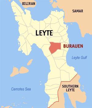
Burauen is a 2nd class municipality in the province of Leyte, Philippines. According to the 2007 census, it has a population of 48,606 people in 9,213 households. It is located in the central part of leyte bounded to the north by Dagami, Jaro, and Tabon-tabon, on the east by Julita, McArthur, Javier, and on the west by Baybay, Albuera and Ormoc.
www.youtube.com/watch?v=EvCBCLdZ1eA
www.youtube.com/watch?v=EvCBCLdZ1eA
Wikipedia article: http://en.wikipedia.org/wiki/Burauen,_Leyte
Nearby cities:
Coordinates: 10°57'14"N 124°51'12"E
- Claveria, Misamis Oriental 231 km
- Impasug-ong Bukidnon 262 km
- Talakag, Bukidnon 298 km
- Kapalong 336 km
- Carmen, Cotabato 383 km
- Baganga, Davao Oriental 384 km
- Banaybanay, Davao Oriental 426 km
- Malungon, Sarangani 491 km
- Lake Sebu, South Cotabato 511 km
- Jose Abad Santos, Davao Occidental 549 km
- Burauen Public Cemetery 5.2 km
- Burauen Comprehensive National High School 5.4 km
- Eastern Visayas State University- Burauen Campus 6.3 km
- Mount Lobi 7.2 km
- Mahagnao Volcano 8.5 km
- Mahagnao Volcano Natural Park 8.5 km
- julita leyte 12 km
- Brgy. Sta. Cruz, Julita, Leyte 12 km
- brgy talisay mayorga leyte 14 km
- Mount Tinagan 15 km
Comments