AN/TPS-71 ROTHR (Relocatable Over-the-Horizon Radar) Transmitter Site
USA /
Virginia /
Hillsboro /
World
/ USA
/ Virginia
/ Hillsboro
World / United States / Virginia
military, radar station
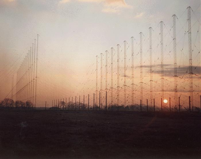
The ROTHR Virginia surveillance area covers more than 2.2 million square miles of the Caribbean extending north-south from southern Florida to the northern coast of South America and east-west from the western coast of Central America to the Lesser Antilles. This coverage is achieved using 5-to-28-MHz radio waves that reflect from the ionosphere. ROTHR is a land-based, high-frequency (HF) radar which can cover a 64-degree wedge-shaped area at ranges of 500 to 1,600 nautical miles. This extended range is achieved when transmitted HF energy is refracted by the ionosphere onto distant targets. The faint energy reflected back from these targets (backscatter) is detected by the radar receive antenna after returning along the refraction path. The surface of the earth and the targets in the area of interest reflect some of this energy back through the ionosphere to a separate receive site, where it is processed to generate target track information.
The High Frequency Band (3 to 30 MHz) is a candidate for radar because it enables surface to surface radar to target distances well beyond the horizon. Radar to target ranges of 1000 nmi and more are typical. Use of the 10 to 60 meter wavelengths associated with HF radar requires physically large antennas. Each ROTHR achieves a nominal half degree azimuth angular resolution with a 2.58-km-long linear phased receiving array consisting of 372 twin-monopole elements. Each monopole pair has a receiver and analog-to-digital converter attached to it. A digital beamformer forms 18 beams which are then Doppler processed to separate the moving targets from the ground clutter. Range resolution is achieved by transmitting a 25-kHz continuous frequency-modulated waveform. A radar resolution cell on the ocean surface is therefore about 6 km in range by about 15 km in azimuth, for the frequency and range used. Radar frequency is variable and is selected using real-time sweep frequency ionospheric soundings.
www.globalsecurity.org/wmd/systems/an-tps-71.htm
Receiver site is here... wikimapia.org/#lat=36.5581188&lon=-76.2749434&z=15&l=0...
Nearby cities:
Coordinates: 37°33'47"N 77°1'26"W
- Virginia Air National Guard 26 km
- Army National Guard Aviation Support Facility 27 km
- Munitions storage 27 km
- Fort Pocahontas/ Battle of Wilson's Wharf 29 km
- City Point Unit of the Petersburg National Battlefield 35 km
- Camp Peary (a.k.a. "The Farm") - CIA Training Facility 35 km
- U.S. Army Ordnance Training and Heritage Center 41 km
- Fort Lee 42 km
- Ordinance storage 44 km
- Fort Lee Post Exchange (PX) 44 km
- New Kent County, Virginia 7.1 km
- King William County, Virginia 18 km
- King and Queen County, Virginia 19 km
- Charles City County, Virginia 23 km
- Highland Springs 28 km
- Mechanicsville, Virginia 30 km
- East Highland Park 31 km
- Henrico County, Virginia 35 km
- Hanover County, Virginia 45 km
- Chesterfield County, Virginia 51 km