KLEIN CURAÇAO Lighthouse
Netherlands Antilles /
Curacao /
Oostpunt /
World
/ Netherlands Antilles
/ Curacao
/ Oostpunt
lighthouse, abandoned / shut down
Klein Curaçao (Little Curaçao)
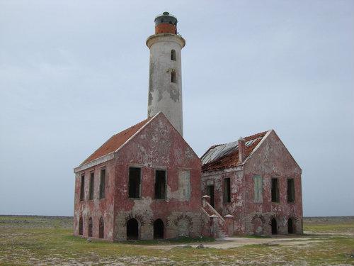
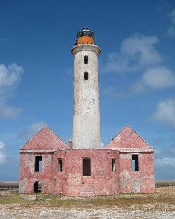
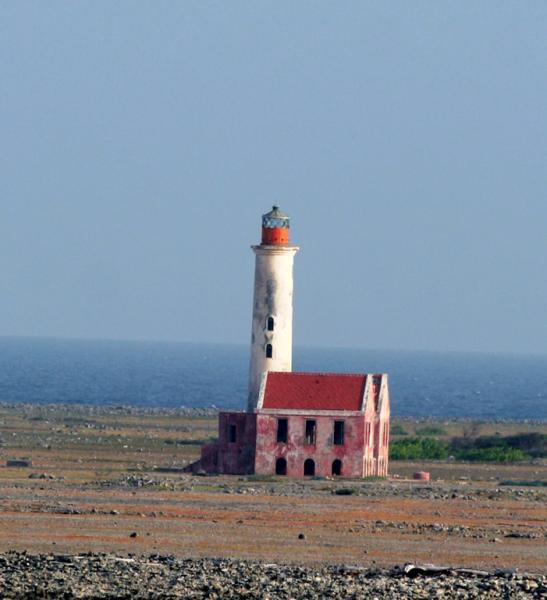
1850 (rebuilt in 1879 and again in 1913). Reactivated; focal plane 25 m (82 ft); two white flashes every 15 s. 20 m (66 ft) round masonry tower with lantern and gallery, connected to two ruined 2-story keepers houses. The lighthouse is white with a rusty red lantern; the keeper's houses are red. Mingo Hagen's 2008 photo is above, Gordon Crago has an August 2004 photo, Trabas has Captain Theo Hinrichs's photo, Confluence.org has a good view of the island and lighthouse, and Google has a good satellite view. Previously abandoned and still endangered, this historic lighthouse was nonetheless reactivated with a solar-powered LED beacon in the restoration of Curaçao's aids to navigation. Recent photos show the keeper's houses to be crumbling rapidly. The barren island of Klein Curaçao is located 11 km (7 mi) off the southeastern tip of Curaçao. Located at the center of the island. Accessible only by boat. Site open; the tower was open prior to reactivation but may be closed now. ARLHS NEA-006; Admiralty J6399; NGA 16054.
1850 (rebuilt in 1879 and again in 1913). Reactivated; focal plane 25 m (82 ft); two white flashes every 15 s. 20 m (66 ft) round masonry tower with lantern and gallery, connected to two ruined 2-story keepers houses. The lighthouse is white with a rusty red lantern; the keeper's houses are red. Mingo Hagen's 2008 photo is above, Gordon Crago has an August 2004 photo, Trabas has Captain Theo Hinrichs's photo, Confluence.org has a good view of the island and lighthouse, and Google has a good satellite view. Previously abandoned and still endangered, this historic lighthouse was nonetheless reactivated with a solar-powered LED beacon in the restoration of Curaçao's aids to navigation. Recent photos show the keeper's houses to be crumbling rapidly. The barren island of Klein Curaçao is located 11 km (7 mi) off the southeastern tip of Curaçao. Located at the center of the island. Accessible only by boat. Site open; the tower was open prior to reactivation but may be closed now. ARLHS NEA-006; Admiralty J6399; NGA 16054.
Nearby cities:
Coordinates: 11°59'23"N 68°38'35"W
- Hooiberg Light 158 km
- Christopher Columbus Tomb Museum and lighthouse 734 km
- Christopher Columbus Lighthouse 735 km
- Punta Maisí Lighthouse 1091 km
- Lighthouse Grounds 1117 km
- Guantanamo Bay Lighthouse Museum 1123 km
- Lover's Leap Lighthouse 1170 km
- Carapachibey lighthouse 1849 km
- Faro de Zacatillo 2082 km
- GLOVER REEF SW Cays Light 2136 km
- Klein Curaçao 0.1 km
- Fuikbaai 22 km
- Old Quarry Golf Course 23 km
- Sint Joris baai 24 km
- Caracas Bay 26 km
- Lagun Jan Thiel 28 km
- Santa Rosa 29 km
- Koraalspecht 30 km
- Sun Valley and Sun Set Heights 35 km
- Curaçao 42 km