Perkiomen Valley (N10)
USA /
Pennsylvania /
Evansburg /
Collegeville Pike, 767
World
/ USA
/ Pennsylvania
/ Evansburg
World / United States / Pennsylvania
airport
Add category
Airport Identifier: N10
Elevation: 277 ft / 84.43 m (Estimated)
Land: 60 acres
From nearest city: 2 nautical miles NE of Collegeville, PA
Location: Montgomery County, PA
Magnetic Variation: 11W (1985)
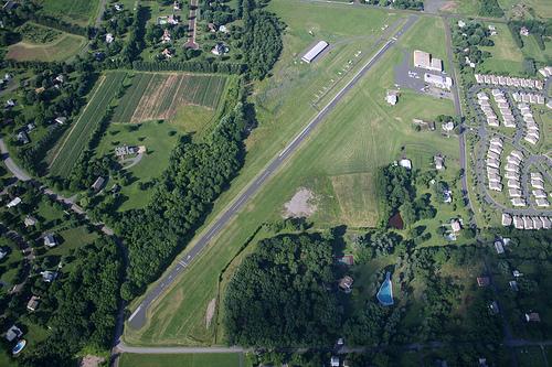
Perkiomen Valley Airport (FAA LID: N10) is a public use airport located two nautical miles (3.7 km) northeast of the central business district of Collegeville, in Montgomery County, Pennsylvania, United States.It is privately owned by the estate of Lane R. Jubb. The airport was opened on March 1, 1938.
Perkiomen Valley Airport (N10)
767 Collegeville Pike, Collegeville, PA 19426
(610) 489-6011
www.perkiomenairport.com/
www.airport-data.com/airport/N10
Elevation: 277 ft / 84.43 m (Estimated)
Land: 60 acres
From nearest city: 2 nautical miles NE of Collegeville, PA
Location: Montgomery County, PA
Magnetic Variation: 11W (1985)
Perkiomen Valley Airport (FAA LID: N10) is a public use airport located two nautical miles (3.7 km) northeast of the central business district of Collegeville, in Montgomery County, Pennsylvania, United States.It is privately owned by the estate of Lane R. Jubb. The airport was opened on March 1, 1938.
Perkiomen Valley Airport (N10)
767 Collegeville Pike, Collegeville, PA 19426
(610) 489-6011
www.perkiomenairport.com/
www.airport-data.com/airport/N10
Wikipedia article: http://en.wikipedia.org/wiki/Perkiomen_Valley_Airport
Nearby cities:
Coordinates: 40°12'16"N 75°25'48"W
- Philadelphia International Airport (PHL/KPHL) 37 km
- Lehigh Valley International Airport (ABE/KABE) 51 km
- New Castle Airport (KILG/ILG) 59 km
- McGuire Air Force Base (WRI/KWRI) 72 km
- Atlantic City International Airport 108 km
- Morristown Municipal Airport (MMU) 109 km
- Dover Air Force Base (KDOV/DOV) 118 km
- Newark Liberty International Airport (EWR/KEWR) 119 km
- Floyd Bennett Field (NOP) 137 km
- John F. Kennedy International Airport (JFK/KJFK) 145 km
- Evansburg State Park 2.3 km
- Perkiomen Township 4.5 km
- Upper Providence Township 6.3 km
- Montgomery County, Pennsylvania 6.4 km
- Harleysville, Pennsylvania 9 km
- Sanatoga, Pennsylvania 14 km
- Gilbertsville, Pennsylvania 20 km
- Bucks County, Pennsylvania 31 km
- Chester County, Pennsylvania 37 km
- Berks County, Pennsylvania 52 km