Abaga Falls (Iligan City)
Philippines /
Central Mindanao /
Iligan /
Iligan City
World
/ Philippines
/ Central Mindanao
/ Iligan
World / Philippines / Lanao del Norte / Iligan City
waterfall, interesting place
Location: Brgy. Suarez, Iligan City, Lanao Del Norte
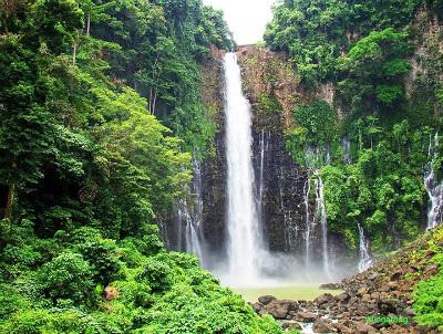
Abaga Falls is a waterfall and ecosystem located approximately 15 km southwest of Iligan City on the island of Mindanao, Philippines. The height of Abaga Falls is approximately twice that of the more famous Maria Christina falls also located within the proximity of Iligan City. Unlike Maria Christina falls however, which is fed by the Agus river, the water source for Abaga Falls is the product of several underground springs which flow into the top Abaga falls via several tributaries.
Unlike like the more popular Maria Cristina falls, human access to Abaga Falls is severely limited due to a current lack of regularly maintained roads as well as the fact that a moderate amount of walking is required to reach the base of the falls. Unfortunately, this level of isolation has not protected the ecosystem from damage due to deforestation and over-hunting.
The name may have been derived from the Cebuano term "abaga" which means "shoulder" possibly relating to the shape and height of the cliff.
Before WWII there was a road that can drive along the rim of the crater and watch the abundance of wild life. The vertical drop of the waterfall is approx. twice or more than that of Maria Cristina Falls. Additional water from Agus River at Baloi be tap,and flow the water through the existing water bed to Abaga Falls. Future usage of hydro plant and agri.irrigation system.
Nearby cities:
Coordinates: 8°9'10"N 124°13'7"E
- Dive site: Cervera Shoal or Snake Island 153 km
- Dive site: Garden Eels 158 km
- Man Made Forest 171 km
- Laak Poblacion 174 km
- Chocolate Hills 200 km
- Mabinian's 2004 - 2005 Ranch 208 km
- Surigao Strait 233 km
- Lake Danao (Cebu) 282 km
- Ponson Island 298 km
- Leyte Gulf 346 km
- Upper Tominobo 2.3 km
- Proper upper Tominobo 2.4 km
- Zone Meteor 3 km
- Maria Cristina 3.1 km
- Suarez 3.2 km
- Ditucalan 3.7 km
- Sta. Elena (Purok 4 & 5) 4 km
- Santa Elena (Tominobo-Ilaya) 4.3 km
- Balo-i, Lanao del Norte 4.5 km
- Suarez Hills 5 km
Comments