Saguling Lake
Indonesia /
Jawa Barat /
Batu Jajar /
World
/ Indonesia
/ Jawa Barat
/ Batu Jajar
World / Indonesia / Jawa Barat
reservoir lake, dam
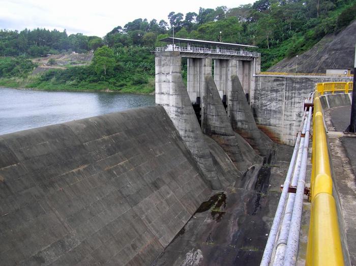

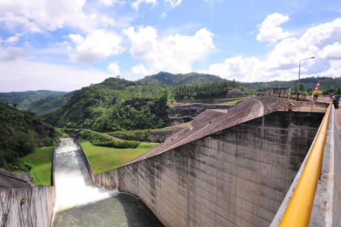


The Saguling is an artificial lake. It is located about 40 km from Bandung city, or about 12 km to the south of the main road from Bandung to Jakarta, and about 90 km at the upstream of the Jatiluhur Lake. The lake was built on the Citarum River, the largest river in West Java Province, in February 1985.
Originally, the Saguling was planned for a single purpose dam to generate electricity. At the first stage the plant was built with an installed capacity of 700 MW, but if the demand of electricity might increasing in the future the plant could be extended to produce 1,400 MW. The responsible body in charge of construction is "Proyek Induk Pembangkit Hidro" abbreviated as PIKITDRO (Main Project of Hydroelectric Development) of the State Electrical Company, of the Ministry of Mining and Energy. Later, considering the environmental problems of the area, the Saguling was re-planned as a multipurpose dam, which included the use of the lake created by the project for other development purposes such as fisheries, agri-aquaculture, tourism and their multiple effects. But, at present, the lake is also used for domestic purposes such as bathing and washing, or also for toilet.
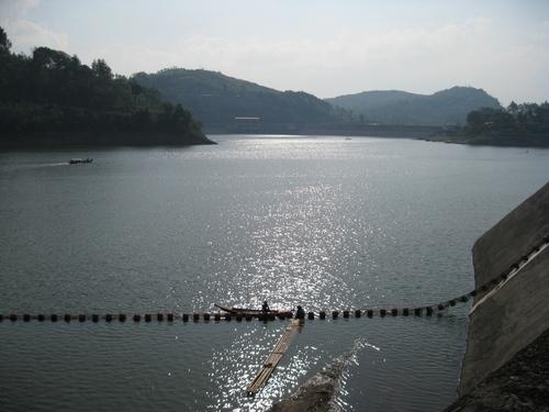
The surrounding area of Lake Saguling is hilly, while the river has many tributaries at this location. This makes the shape of Lake Saguling very irregular or dendritic, with many extended bays. The lake area was formerly densely populated by farmer population with extensive agricultural lands. The catchment areas of the lake or the upper Citarum River basin are faced with high population pressure. This is because over 50% of the population consists of farmers with a high annual growth rate (2.34% is the national average). The growth of farmer population has caused the decrease of landholding and this condition forced them to extend their agricultural land by forest clearing and utilize marginal lands. As a consequence, there is a prevailing problem of floods accompanied by accelerated soil erosion in rainy seasons. The Institute of Ecology at Bandung has been studying the area since 1978, dealing with basic conditions of the area and also environmental monitoring and management for enhancing the living standard of the population.
Due to the high population density in the upper catchment of the lake, extensive agricultural land, soil erosion and the presence of industries,the lake water became polluted and eutrophic. The growth of aquatic weeds has been accelerated,with frequent blooms of Microcystis algae. The water is also contaminated by heavy metals, pesticides, etc. An extensive growth of water- hyacinth is maintained by fencing to reduce pollutant contents of water at inlets of the Citarum River (Q).
Originally, the Saguling was planned for a single purpose dam to generate electricity. At the first stage the plant was built with an installed capacity of 700 MW, but if the demand of electricity might increasing in the future the plant could be extended to produce 1,400 MW. The responsible body in charge of construction is "Proyek Induk Pembangkit Hidro" abbreviated as PIKITDRO (Main Project of Hydroelectric Development) of the State Electrical Company, of the Ministry of Mining and Energy. Later, considering the environmental problems of the area, the Saguling was re-planned as a multipurpose dam, which included the use of the lake created by the project for other development purposes such as fisheries, agri-aquaculture, tourism and their multiple effects. But, at present, the lake is also used for domestic purposes such as bathing and washing, or also for toilet.
The surrounding area of Lake Saguling is hilly, while the river has many tributaries at this location. This makes the shape of Lake Saguling very irregular or dendritic, with many extended bays. The lake area was formerly densely populated by farmer population with extensive agricultural lands. The catchment areas of the lake or the upper Citarum River basin are faced with high population pressure. This is because over 50% of the population consists of farmers with a high annual growth rate (2.34% is the national average). The growth of farmer population has caused the decrease of landholding and this condition forced them to extend their agricultural land by forest clearing and utilize marginal lands. As a consequence, there is a prevailing problem of floods accompanied by accelerated soil erosion in rainy seasons. The Institute of Ecology at Bandung has been studying the area since 1978, dealing with basic conditions of the area and also environmental monitoring and management for enhancing the living standard of the population.
Due to the high population density in the upper catchment of the lake, extensive agricultural land, soil erosion and the presence of industries,the lake water became polluted and eutrophic. The growth of aquatic weeds has been accelerated,with frequent blooms of Microcystis algae. The water is also contaminated by heavy metals, pesticides, etc. An extensive growth of water- hyacinth is maintained by fencing to reduce pollutant contents of water at inlets of the Citarum River (Q).
Wikipedia article: http://en.wikipedia.org/wiki/Saguling_Dam
Nearby cities:
Coordinates: 6°55'52"S 107°26'24"E
- Cirata Reservoir 34 km
- Jatiluhur Dam 46 km
- Waduk Jatigede 69 km
- Jatigede Dam 72 km
- Cipancuh Reservoir 73 km
- Waduk Darma 106 km
- Malahayu Reservoir 150 km
- Cacaban Reservoir 193 km
- Sempor Reservoir 234 km
- Mrica Reservoir 244 km
- Kampungnya Kang Pandi 1.8 km
- Desa Pasir Tugu neyh Desa na Mantan Abdi Nenk Risma 3.6 km
- kampung ciheulang 4 km
- cikadu "malam indah terang bulan" tapi jalannya ancuuurrrrrrrr....Diperbaiki Sudah Mau Rusak lagi...Parraaahhh Korupsina !!! 4.4 km
- citiis 4.4 km
- kp bojong sempur rt 1,2,3 rw 05 4.5 km
- KP. MEKARSALUYU 4.7 km
- KMP BOJONG MAREME KALER 5.1 km
- desa kelahiranku IVAN HADI SANTOSO dari pasangan Supardi bin Ngarpan dengan Oti Rohaiti binti Tarna. 5.1 km
- West Bandung Regency 8 km
Kampungnya Kang Pandi
Desa Pasir Tugu neyh Desa na Mantan Abdi Nenk Risma
kampung ciheulang
cikadu "malam indah terang bulan" tapi jalannya ancuuurrrrrrrr....Diperbaiki Sudah Mau Rusak lagi...Parraaahhh Korupsina !!!
citiis
kp bojong sempur rt 1,2,3 rw 05
KP. MEKARSALUYU
KMP BOJONG MAREME KALER
desa kelahiranku IVAN HADI SANTOSO dari pasangan Supardi bin Ngarpan dengan Oti Rohaiti binti Tarna.
West Bandung Regency
Comments