Site of the Albert Barracks
New Zealand /
Auckland /
World
/ New Zealand
/ Auckland
/ Auckland
World / New Zealand / Auckland / Waitakere
historical layer / disappeared object
Add category
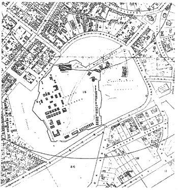
19th century military fortification which was dismantled in the 1870s. Most of the land was used to create Albert Park. A small portion of the defensive wall still survives.
Nearby cities:
Coordinates: 36°51'4"S 174°46'5"E
- Totara Riding 76 km
- Canada Bay Council 2171 km
- "Sandy Island" (Ghost Island) 2450 km
- Willunga Hill Bushfire 13/4/2008 3242 km
- Port Lincoln Fire 23 Dec 2009 3502 km
- Maytown 3787 km
- Maclay house (1871-72, 1876) 4569 km
- Epicenter of Earthquake Situbondo / Oct 11, 2018 (M=6.4) 6855 km
- WILAYAH KEKUASAAN KI AGENG MANGIR WONOBOYO dahulu kala 7238 km
- Kingdom of Srivijaya 8131 km
- Albert Park 0.1 km
- University of Auckland (City Campus) 0.2 km
- Auckland City Central Business District 0.3 km
- auckland 0.7 km
- Viaduct Harbour 1.1 km
- Victoria Quarter 1.1 km
- Viaduct Basin 1.2 km
- Wynyard Quarter 1.5 km
- Waitematā Harbour Restricted Zone 2.4 km
- Waitemata Harbour 4.1 km