Angel Mounds State Historic Site
| memorial, NRHP - National Register of Historic Places, earthwork (archaeology), state park, U.S. National Historic Landmark
USA /
Indiana /
Newburgh /
Pollack Avenue, 8215
World
/ USA
/ Indiana
/ Newburgh
World / United States / Indiana
memorial, NRHP - National Register of Historic Places, earthwork (archaeology), state park, U.S. National Historic Landmark


8215 Pollack Avenue
Evansville, IN 47715
(812) 853-3956
www.angelmounds.org/
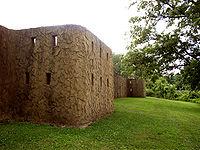
The 600+ acres that comprise Angel Mounds State Historic Site were purchased in 1938 by the Indiana Historical Society with financial assistance from Eli Lilly. In 1947, the Indiana Historical Society transferred ownership to the State of Indiana. It is now managed and interpreted by the Indiana State Museum and Historic Sites. Indiana University is responsible for excavations and research on the site.
History of the Area:
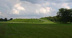
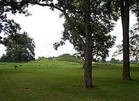
Five to seven hundred years ago, the area we now call Angel Mounds State Historic Site was a thriving Mississippian Indian town. Built between A.D. 1100 and 1300, the town was occupied by one thousand to three thousand inhabitants until its abandonment around 1450. Throughout that time, it was the largest settlement in Indiana. It served as the center of trade, government and religion for smaller satellite communities within a 70-mile radius.
Mississippian culture originated in the southeastern United States between A.D. 700 and 800, and in some places survived as late as 1700. The culture was very innovative. It was the first to extensively exploit agriculture and build permanent communities with thousands of residents. This economic and social system was made possible by the widespread cultivation of corn, a crop nutritious enough to be a dietary staple and capable of being harvested and stored in large quantities. The large and important town at Angel Mounds lends its name to the Angel phase, the period of Mississippian culture found near the confluence of the Wabash and Ohio Rivers from the late 11th through the early 15th century.
After more than 200 years of constant occupation, the town at Angel Mounds was abandoned, and by 1450, the site was empty. There is no evidence to show why the inhabitants left. Over a long period of occupation, the local supply of wood for building and fire would have been severely depleted. Intense agriculture may have overworked the soil. Game may have been scarce from over hunting. Although there is no indication of attack from outside, there may have been political upheavals from within. Some combination of these factors, or perhaps all, may have played a role in the town’s desertion.
The Mississippian people did not disappear entirely from Indiana; however, their lifestyle changed. The center of population also shifted 30 miles to the west of Angel Mounds where dispersed farmsteads and villages continued to exist along the Ohio River through the early 1600s. These later Mississippians were also gone before the arrival of Europeans in Indiana.
Evansville, IN 47715
(812) 853-3956
www.angelmounds.org/
The 600+ acres that comprise Angel Mounds State Historic Site were purchased in 1938 by the Indiana Historical Society with financial assistance from Eli Lilly. In 1947, the Indiana Historical Society transferred ownership to the State of Indiana. It is now managed and interpreted by the Indiana State Museum and Historic Sites. Indiana University is responsible for excavations and research on the site.
History of the Area:
Five to seven hundred years ago, the area we now call Angel Mounds State Historic Site was a thriving Mississippian Indian town. Built between A.D. 1100 and 1300, the town was occupied by one thousand to three thousand inhabitants until its abandonment around 1450. Throughout that time, it was the largest settlement in Indiana. It served as the center of trade, government and religion for smaller satellite communities within a 70-mile radius.
Mississippian culture originated in the southeastern United States between A.D. 700 and 800, and in some places survived as late as 1700. The culture was very innovative. It was the first to extensively exploit agriculture and build permanent communities with thousands of residents. This economic and social system was made possible by the widespread cultivation of corn, a crop nutritious enough to be a dietary staple and capable of being harvested and stored in large quantities. The large and important town at Angel Mounds lends its name to the Angel phase, the period of Mississippian culture found near the confluence of the Wabash and Ohio Rivers from the late 11th through the early 15th century.
After more than 200 years of constant occupation, the town at Angel Mounds was abandoned, and by 1450, the site was empty. There is no evidence to show why the inhabitants left. Over a long period of occupation, the local supply of wood for building and fire would have been severely depleted. Intense agriculture may have overworked the soil. Game may have been scarce from over hunting. Although there is no indication of attack from outside, there may have been political upheavals from within. Some combination of these factors, or perhaps all, may have played a role in the town’s desertion.
The Mississippian people did not disappear entirely from Indiana; however, their lifestyle changed. The center of population also shifted 30 miles to the west of Angel Mounds where dispersed farmsteads and villages continued to exist along the Ohio River through the early 1600s. These later Mississippians were also gone before the arrival of Europeans in Indiana.
Wikipedia article: https://en.wikipedia.org/wiki/Angel_Mounds
Nearby cities:
Coordinates: 37°56'24"N 87°27'29"W
- Morgan-Monroe State Forest 180 km
- Natural Bridge State Resort Park 317 km
- Max Patch Mountain State Park 452 km
- Gorges State Park 506 km
- Ohiopyle State Park 720 km
- Game Land State Park 941 km
- Osceola National Forest 952 km
- Waccasassa Bay Preserve State Park 1056 km
- Crystal River Preserve State Park 1091 km
- Fakahatchee Strand Preserve State Park 1426 km
- Interstate 69 (Former I-164) Exits 7A & 7B - Lloyd Expressway (Indianda 66) 4 km
- Lloyd Crossing 4.5 km
- Evansville State Hospital 5.5 km
- Wesselman Woods Nature Preserve 6.6 km
- University of Evansville 7.4 km
- "Green River Island" 7.9 km
- Oak Hill Cemetery 8.5 km
- Vanderburgh County, Indiana 12 km
- Henderson County, Kentucky 19 km
- Warrick County, Indiana 23 km