James Cook (Gisborne)
New Zealand /
Gisborne /
Gisborne
World
/ New Zealand
/ Gisborne
/ Gisborne
World / New Zealand / Gisborne / Gisborne
memorial, monument
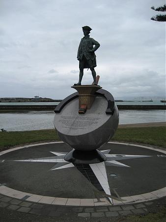
Captain Royal Navy 1728-1779. Quote from part of the plaque:
"Here on the 9th and 10th of October, 1769, Cooked walked with men from HM Bark Endeavour seeking fresh food and water. Nearby on the river rock Toka-a-Taiau Maori chief and English captain greeted one another. When traditional challenges were misunderstood, Maori were killed, the ship sailed without provisions and thus Poverty Bay received its name. From here the Endeavour circumnavigated New Zealand and Cook plotted the first map of this country."
"Here on the 9th and 10th of October, 1769, Cooked walked with men from HM Bark Endeavour seeking fresh food and water. Nearby on the river rock Toka-a-Taiau Maori chief and English captain greeted one another. When traditional challenges were misunderstood, Maori were killed, the ship sailed without provisions and thus Poverty Bay received its name. From here the Endeavour circumnavigated New Zealand and Cook plotted the first map of this country."
Nearby cities:
Coordinates: 38°40'20"S 178°1'21"E
- Pinegrove Memorial Park 2491 km
- Sun Valley 2516 km
- ANZAC Parade 2585 km
- Northern Memorial Park 2880 km
- San Diego Hills Memorial Park 7909 km
- Spioen Kop 11860 km
- National Women's Memorial & Anglo-Boer War Museum 11941 km
- Le Héros sunk here, 7 May, 1942 12300 km
- Fish River Canyon 12388 km
- Twyfelfontein - UNESCO World Heritage Site 13223 km
- Poverty Bay 5.3 km
- Te Tapuwae o Rongokako Marine Reserve 19 km
- Waihau Bay 33 km
- Tolaga Bay/Uawa 43 km
- Anarua Bay 55 km
- Tokomaru Bay 65 km
- Waipiro Bay 78 km
- Omaio Bay 103 km
- Hicks Bay 124 km
- Bay of Plenty 167 km