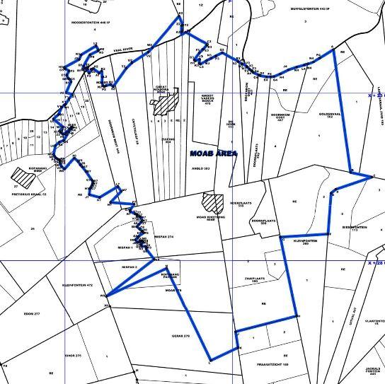
Moab Khotsong Gold Mine
South Africa /
North West /
Stilfontein /
World
/ South Africa
/ North West
/ Stilfontein
World / South Africa / Orange Free State
mine, gold mine
This is the mining right for the Moab Khotsong Gold Mine and also includes the shuttered Great Noligwa mine which was amalgamated with the Moab operations in 2015. At the time Anglo had planned to close and decomission the shaft. Moab was previously owned by AngloGold Ashanti who originally built the mine. On February 28, 2018 Anglo announced they had sold the mine to Harmony Gold in a $300 million deal.
Construction and sinking of the vertical shaft started at Moab in 1991 and mine stoping operations began in November 2003. It consists of a single vertical shaft and mining occurs a depths of up to 3.400 meters. Great Noligwa started producing in 1968 then was put on care and maintenance in 2015. It consists of a twin vertical shaft system with a gold and uranium plant.
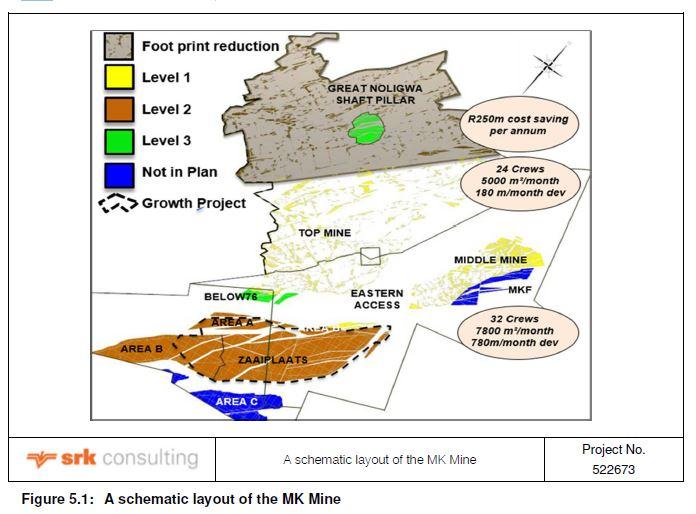
After Great Noligwa was amalgamted with Moab the orebody was divided in 3 distint zones based on major faulting. Top Mine is comprised of most of the Great Noligwa workings, Middle mine is essentially the current Moab workings, and Zaaiplaats which is undeveloped and lies south-west of the current Moab infrastructure and below 100 level. Due to the complex nature of the orebodies because of faultiing the scattered mining method is utilized, together with an integrated backfill support system that incorporates bracket pillars. The mined zones occur anywhere between 1,791 m and 3,052 m below surface.
One key operating cost for this and other mines in the immediate area is the pumping of water in order to keep their workings from flooding from water sources outside the mine. Local miners share an interest in the Margaret Water Company which owns and operates the Margaret Shaft at the old Stilfontein Gold Mine. Around 80% of water pumped for dewatering the locad KOSH (Klerksdorp-Orkney-Stilfontein-Hartebeestfontein) area underground workings is pumped from the Margaret shaft.
Regionally Moab is located in the Witwatersrand Basin which is a late Archean-aged basin that is comprised of an inter-bedded sequence of arenaceous and argillaceous sediments. The basin is located on the Kaapvaal Craton and is 6 km thick, 300 km wide from northeast to southwest, and 100 km wide northwest to southeast. All sections of the basin except the northern section are overlain by 4km of volcanic and sedimentary rocks from the Archaean, Proterozoic and Mesozoic period.
Locally most mining at Moab is conducted on the V Reef with some mining on the C Reef. Both reefs are narrow tabular deposits forming part of the Witwatersrand Supergroup and are stratigraphically located near the middle of the Central Rand Group. The V typically occurs at approximately 255 m below the C Reef. Mining at Great Noligwa, or Top of Mine, occurs in the Vaal Reef and the Crystalkop Reef. Mineralization was a result of gold precipitation conglomerates from hydrothermal fluids. Precipiation of the gold andother elements was the result of reactions that took place at high temperatures ranging between 300 to 350°C.
Construction and sinking of the vertical shaft started at Moab in 1991 and mine stoping operations began in November 2003. It consists of a single vertical shaft and mining occurs a depths of up to 3.400 meters. Great Noligwa started producing in 1968 then was put on care and maintenance in 2015. It consists of a twin vertical shaft system with a gold and uranium plant.
After Great Noligwa was amalgamted with Moab the orebody was divided in 3 distint zones based on major faulting. Top Mine is comprised of most of the Great Noligwa workings, Middle mine is essentially the current Moab workings, and Zaaiplaats which is undeveloped and lies south-west of the current Moab infrastructure and below 100 level. Due to the complex nature of the orebodies because of faultiing the scattered mining method is utilized, together with an integrated backfill support system that incorporates bracket pillars. The mined zones occur anywhere between 1,791 m and 3,052 m below surface.
One key operating cost for this and other mines in the immediate area is the pumping of water in order to keep their workings from flooding from water sources outside the mine. Local miners share an interest in the Margaret Water Company which owns and operates the Margaret Shaft at the old Stilfontein Gold Mine. Around 80% of water pumped for dewatering the locad KOSH (Klerksdorp-Orkney-Stilfontein-Hartebeestfontein) area underground workings is pumped from the Margaret shaft.
Regionally Moab is located in the Witwatersrand Basin which is a late Archean-aged basin that is comprised of an inter-bedded sequence of arenaceous and argillaceous sediments. The basin is located on the Kaapvaal Craton and is 6 km thick, 300 km wide from northeast to southwest, and 100 km wide northwest to southeast. All sections of the basin except the northern section are overlain by 4km of volcanic and sedimentary rocks from the Archaean, Proterozoic and Mesozoic period.
Locally most mining at Moab is conducted on the V Reef with some mining on the C Reef. Both reefs are narrow tabular deposits forming part of the Witwatersrand Supergroup and are stratigraphically located near the middle of the Central Rand Group. The V typically occurs at approximately 255 m below the C Reef. Mining at Great Noligwa, or Top of Mine, occurs in the Vaal Reef and the Crystalkop Reef. Mineralization was a result of gold precipitation conglomerates from hydrothermal fluids. Precipiation of the gold andother elements was the result of reactions that took place at high temperatures ranging between 300 to 350°C.
Nearby cities:
Coordinates: 26°58'58"S 26°48'10"E
- Buffelsfontein Gold Mine - Buffelsfontein 15 km
- Orkney Gold Mine 21 km
- Driefontein Division 94 km
- Kloof Gold Mine 107 km
- Rand Uranium Mine 129 km
- Marikana Platinum Mine 164 km
- Impala Platinum Mine 186 km
- Union Platinum Mine 234 km
- Tumela Platinum Mine 252 km
- Zondereinde Platinum Mine 253 km
- African Explosives Limited (AEL) 6.5 km
- Kareerand Mega Dam TSF 14 km
- Potchefstroom Agricultural College 38 km
- Promosa 39 km
- Artillery Shooting Range 45 km
- Boschkop Dam 58 km
- Vredefort impact crater 64 km
- Klipdrift Dam 65 km
- Wedela 82 km
- Mponeng TSFs 84 km