Miyakejima Island
Japan /
Shizuoka /
Shimoda /
World
/ Japan
/ Shizuoka
/ Shimoda
World / Japan / Shizuoka
island, volcano
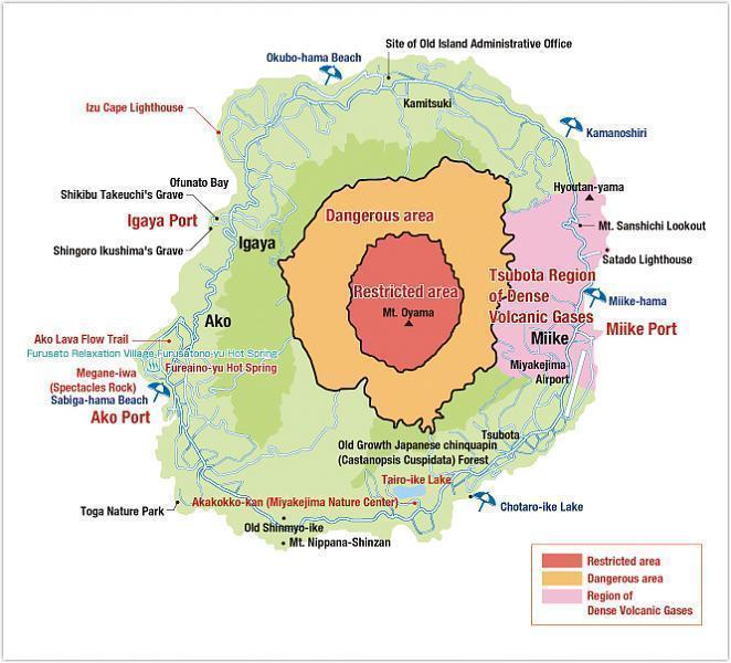
Miyakejima is an island in the Izu group, southeast of Honshū, Japan, administered by the Tokyo Metropolitan government, with an area of 55.50km². The island, 180km south of Tokyo, is located at 34.5N and 139.34E. As of January 1st, 2006, the population of the island is 2884. Like other islands in the Izu Island group, Miyakejima forms part of the Fuji-Hakone-Izu National Park.
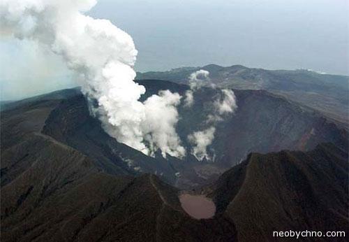
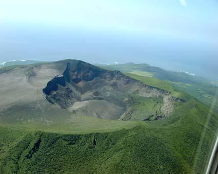
The island is a basalt stratovolcanic in origin, and the main volcano, Mount Oyama, has erupted several times in recent history. A lava flow in 1940 killed 11 people, and other eruptions occurred in 1962 and 1983. On July 14, 2000, Mount Oyama began another series of eruptions, and by September, the island was completely evacuated. After a four-year period of volcanic emissions, residents were allowed to return permanently on February 1, 2005. After the eruption, there has been a constant flow of sulfuric gas coming from Mount Oyama.
The island is a basalt stratovolcanic in origin, and the main volcano, Mount Oyama, has erupted several times in recent history. A lava flow in 1940 killed 11 people, and other eruptions occurred in 1962 and 1983. On July 14, 2000, Mount Oyama began another series of eruptions, and by September, the island was completely evacuated. After a four-year period of volcanic emissions, residents were allowed to return permanently on February 1, 2005. After the eruption, there has been a constant flow of sulfuric gas coming from Mount Oyama.
Wikipedia article: http://en.wikipedia.org/wiki/Miyake-jima
Nearby cities:
Coordinates: 34°5'7"N 139°31'14"E
- Mikurajima island 21 km
- Kozushima Island 41 km
- Niijima island 46 km
- Izu Oshima island 81 km
- Hachijo Island 105 km
- Noto Island 417 km
- Sado Island 488 km
- Chichi-jima island 818 km
- Haha-jima island 857 km
- Iwo To / Iwo Jima 1046 km
- Mt. Oyama 0.5 km
- Mikurajima Volcano, 851 m 25 km
- Mt.Takadokoro, 288 m 37 km
- Kozu-shima Volcano, 572 m 37 km
- Kando mountain, 269 m. 39 km
- Mt. Hachijo-Fuji 108 km
- Hachijojima Airport 111 km
- Mt. Mihara 114 km
- Aogashima Volcano, 423 m 183 km
- Place of death of the M / V "Tixi" 247 km