Condor Field (site)
USA /
California /
Twentynine Palms Base /
World
/ USA
/ California
/ Twentynine Palms Base
World / United States / California
military
Add category


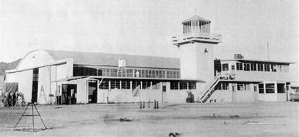
On the property of the Marine Corps' sprawling Twentynine Palms Air-Ground Combat Center, its original military airfield is now barely evident. It was built on the southeast edge of Mesquite Lake, in what is now the Mainside area of the Twentynine Palms Base.
The date of construction of this airfield has not been determined. It was evidently built at some point between 1937-41, as no airfield at this location was listed in the Airport Directory Company's 1937 Airports Directory (courtesy of Bob Rambo). By 1941, a civil field named "Twenty Nine Palms" was depicted on the 1941 LA Sectional Chart (courtesy of Chris Kennedy).
In January 1942, the site of the pre-war civil Twenty Nine Palms airfield was reused as the site of Condor Field, which was established to serve as the primary Army glider school of WW2. The Twentynine Palms Airport (6 miles east) was also used as an auxiliary glider airport by Condor Field during WW2.
Condor Field's mission of training Army glider pilots came to an end in April 1944, and the Army closed their operation at the field. "Condor #1, Army" was listed in the 1944 US Army/Navy Directory of Airfields (courtesy of Ken Mercer), but the remarks said "Closed". It was described as having a 3,000' runway.
After the Army relinquished the field, it was taken over by the Navy in 1944, and was redesignated Twentynine Palms Naval Auxiliary Air Station. Twentynine Palms Naval Auxiliary Air Station was abandoned by the Navy in October 1945.
At some point between 1945-49, the field was reopened as a civil airport. That is how "Twentynine Palms" was depicted on the 1949 Los Angeles Sectional Chart (according to Chris Kennedy). It was described as having a 4,000' hard-surface runway.
In 1952, as part of the Korean War buildup, a need was identified for more expansive ranges to support live-fire training. Condor Field was determined to be a suitable site, and the Marine Corps Training Center Twentynine Palms was established on the site of Condor Field. The airfield at the former Condor Field was expanded as an expeditionary airfield. It was labeled as "Twentynine Palms (Marine)" on the 1964 LA Sectional Chart, and the Aerodromes table on the reverse side of the chart described the field as having two runways, with the longest runway being a 6,000' steel mat.
In 1976, work began to replace the original airfield with a completely new expeditionary airfield, capable of handling any aircraft up to & including the giant C-5 Galaxy transport. The new airfield was built 8 miles northwest of the original airfield. Condor Field was closed in 1976 when the new airfield was opened, according to MCAGCC Twentynine Palms MWSS-374 CWO2 John Lackie.
www.airfields-freeman.com/CA/Airfields_CA_SanBernardino...
Nearby cities:
Coordinates: 34°12'48"N 116°3'13"W
- Warda-Mir Training Facility 4.8 km
- Marine Corps Air Ground Combat Center Twentynine Palms ("Mainside Area") 5.7 km
- Camp Wilson 14 km
- Twentynine Palms Strategic Expeditionary Landing Field (SELF) 15 km
- Outlying Field Seagle 16 km
- Camp Young (site) 64 km
- Chocolate Mountain Aerial Gunnery Range (CMAGR) 83 km
- Borrego Valley Manuever Area 93 km
- Camp Ensign Cantonment Area 110 km
- Naval Air Facility, Salton Sea 115 km
- Mesquite Lake 1.2 km
- Desert Winds Golf Course 5.4 km
- Dead Mans Lake 13 km
- Wonderland of Rocks 20 km
- Johnny Lang Canyon 26 km
- Joshua Tree, California 27 km
- Goat Mountain Summit 30 km
- Lower Covington Flat 31 km
- Upper Covington Flat 33 km
- Joshua Tree National Park 38 km