United 93 Burned Trees Area
USA /
Pennsylvania /
Shanksville /
World
/ USA
/ Pennsylvania
/ Shanksville
World / United States / Pennsylvania
crash site, trees, disaster site
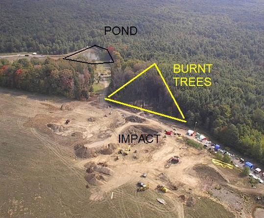
This area of trees was burned by the ensuing fireball after United Airlines flight 93 crashed on September 11, 2001, leaving a distinctive triangular shape.
This area is visible in the photo though the photo has south at the top whereas the WikiMapia map is oriented with north at the top.
This area is visible in the photo though the photo has south at the top whereas the WikiMapia map is oriented with north at the top.
Nearby cities:
Coordinates: 40°3'1"N 78°54'17"W
- Path of EF-3 Tornado 312 km
- Mayfield, Kentucky 927 km
- Tornado Damage Swath - June 7, 2007 1013 km
- Waveland, Mississippi 1443 km
- Part of the bridge blown out 1479 km
- Bermuda Triangle 1559 km
- Wreck of Soviet Submarine K-219 2374 km
- Approximate Crash Site Birgenair 757 Flight 301 February 6,1996 2379 km
- RMS Titanic (point of collision) 2428 km
- Doñana disaster 6142 km
- Stonycreek Township 4.9 km
- Reclaimed Strip Mine 7.6 km
- Quemahoning Township 10 km
- Shade Township 10 km
- Allegheny Township 11 km
- Somerset County, Pennsylvania 12 km
- Paint Township 17 km
- Conemaugh Township 20 km
- Ogle Township 21 km
- Bedford County, Pennsylvania 37 km