Pyrgi
Italy /
Lazio /
Santa Marinella /
World
/ Italy
/ Lazio
/ Santa Marinella
World / Italy / Lazio / Roma
museum, archaeological site
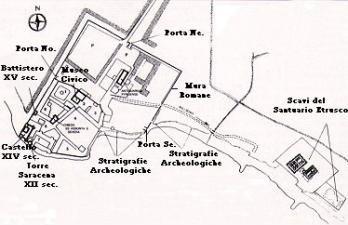
PYRGI (SE of mod. S. SEVERA), an ancient town of Etruria, Italy, on the south-west coast, 9 m. W.N.W. of Caere. The name is Greek (πύργοι, towers), and the place of considerable antiquity. Remains of its defensive walls exist in polygonal blocks of limestone and sandstone, neatly jointed. They enclosed a rectangular area some 200 yds. in width and at least 220 yds. in length. The south-west extremity has probably been destroyed by the sea. It contained a rich temple of Leucothea, the foundation of which was ascribed to the Pelasgi. It was plundered by Dionysius in 384 B.C. Later it became dependent on Caere, though it is not probable that it was originally merely the harbour of Caere; Alsium (q.v.) is a good deal nearer (5 m. south). The Romans planted a colony here, which is first mentioned in 191 B.C. Later still it supplied fish to the capital, and became a favourite summer resort, as did also Punicum (S. Marinella) 5 m. to the north-west, where are many remains of villas. Both were stations on the coast road (Via Aurelia). A sanctuary with two or three temples stood a little down the coast to the south-east.
Wikipedia article: http://en.wikipedia.org/wiki/Pyrgi
Nearby cities:
Coordinates: 42°1'0"N 11°57'31"E
- Italian Air Force Museum "Vigna di Valle" 22 km
- carducci 23 km
- Porto 34 km
- Palazzo della Farnesina - Ministry of Foreign Affairs 42 km
- Vatican Museums 43 km
- Villa Farnesina museum 44 km
- Villa Médicis - Institut de France à Rome 45 km
- Baths of Caracalla 46 km
- Pontifical Palace, Villa Barberini and the Villa Cybo territory 64 km
- Alba Fucens 120 km
- Santa Severa military shooting range 1.7 km
- Macchiatonda 3.1 km
- Military 4.5 km
- Furbara Air Base 5.2 km
- Palude di Torre Flavia (it) 10 km
- A12 exit - Cerveteri / Ladispoli 11 km
- La Boccetta 12 km
- Necropolis of Banditaccia 12 km
- The Necropolis of Mount Abatone 13 km
- Palo's wood 14 km