Site of the Latham Water Tower
USA /
New York /
Cohoes /
World
/ USA
/ New York
/ Cohoes
World / United States / New York
demolished, historical layer / disappeared object
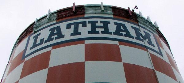
Bearing the name of the town of Latham on its sides and a red and white checkerboard pattern, the Latham Water Tower was a place that attracted both praise for its flamboyance and harsh words from beginner pilots trying to land at Albany Airport. After the east-west runway was extended the tower was considered a hazard by the airport and was demolished in March 2011.
Wikipedia article: http://en.wikipedia.org/wiki/Latham,_NY
Nearby cities:
Coordinates: 42°44'58"N 73°45'59"W
- NYC Harlem Division (Abandoned) 44 km
- Poughkeepsie & Eastern Railway (Abandoned) 77 km
- Poughkeepsie & Connecticut Railroad Right-of-Way 86 km
- Newburgh, Dutchess & Connecticut Railroad (Abandoned) 86 km
- Wallkill Valley Railroad (Mostly Abandoned) 101 km
- NYO&W Railway - Kingston Branch (Abandoned) 106 km
- NYNH&H Maybrook Line (Mostly Abandoned) 118 km
- NYO&W Railway - Main Line (Abandoned) 129 km
- New York, Susquehanna & Western Railway (Abandoned) 214 km
- Lehigh & New England Railroad (Abandoned) 222 km
- Albany International Airport (KALB/ALB) 2.7 km
- Colonie, New York 3.9 km
- Vischer Ferry Nature & Historic Preserve 6.1 km
- Colonie Reservoir 8.8 km
- Niskayuna, New York 10 km
- Clifton Park, New York 13 km
- Halfmoon, New York 13 km
- Guilderland, New York 17 km
- Rensselaer County, New York 19 km
- Albany County, New York 22 km