Contractors Site (Bath)
United Kingdom /
England /
Bath
World
/ United Kingdom
/ England
/ Bath
World / United Kingdom / England
mine, historical layer / disappeared object
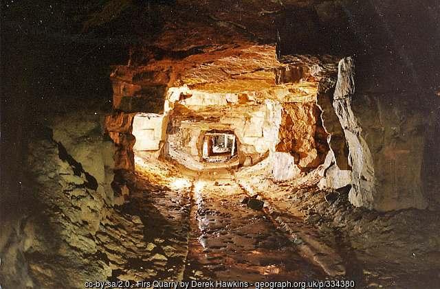
This is the site used by the contractor as a base during the operation to backfill all the old stone mine workings under Combe Down with a cement slurry pumped into place from the main site.
Foamed concrete has been selected as the solution for the large scale infilling of the old mine works. Over 400,000 cubic metres (523,180 cu yd) of foamed concrete will be placed in the shallow underground mines
It was originally a park and all works are now complete with the site returned to its former state.
Kindly move to category [historic layer] once the google satellite image catches up with reality.
Photo: www.geograph.org.uk/photo/334380
Wikipedia article: http://en.wikipedia.org/wiki/Bath_Stone
Nearby cities:
Coordinates: 51°21'41"N 2°20'49"W
- Rhondda Valley 92 km
- Cornish China Clay Belt 211 km
- Tunstead Works 216 km
- Waverley 235 km
- Stobswood Opencast Coal Mine 435 km
- UK Coal - Maidens Hall Site 439 km
- Leadhills 464 km
- Coal Mine 466 km
- Coal Mine 471 km
- Broken Cross - Open cast coal mine 485 km
- Foxhill 0.4 km
- Prior Park College. 0.5 km
- Prior Park Gardens 0.7 km
- Beech Wood 0.7 km
- Priory Wood 1 km
- Beechen Cliff School 1.4 km
- Entry Hill 9 Hole Golf Course 1.5 km
- Cleeve Rocks 1.8 km
- Odd Down Playing Field 1.9 km
- Somerset 53 km