Naikhangchari Upazila HQ (Naikongsari Banderban Bangladesh)
Bangladesh /
Koks Bazar /
Ramu /
Naikongsari Banderban Bangladesh
World
/ Bangladesh
/ Koks Bazar
/ Ramu
World / Bangladesh / Chittagong / Chittagong / Cox's Bazar
township, subdistrict, fourth-level administrative division, local government
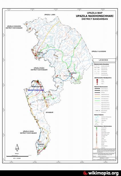
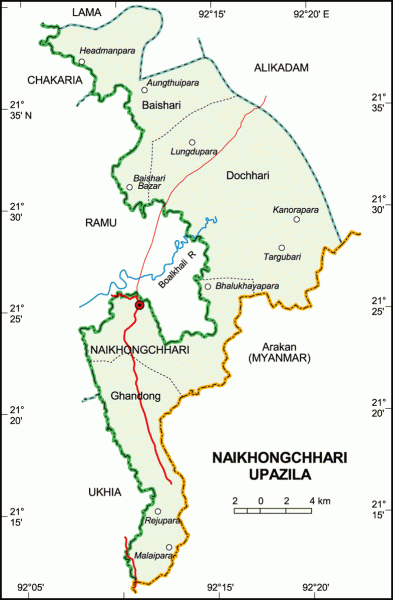
Naikhongchari Upazila (Bandarban district) with an area of 463.61 sq km, is bounded by Matamuhuri reserve forests, Alikadam, Lama and Ramu on the north, the river Naf and Arakan state (Myanmar) on the south, hill regions of north Arakan on the east and Ukhia, Ramu and Chakaria upazilas on the west.
The location of Naikhongchari town is 21.4223354N 92.175293E. Naikhongchari (Town) consist of one mouza with an area of 54.39 sq km. It has a population of 10754; male 55.85%, female 44.15%. The density of population is 198 per sq km. Literacy rate among the town people is 27.9%.
Naikhongchari thana was established in 1923 and turned into an upazila in 1985. It consists of 4 union parishads, 17 mouzas and 135 villages.
As of the 1991 Bangladesh census: Population 38350; male 53.26%, female 46.74%. Muslim 72.91%, Buddist 25.77%, Hindu 1.3%, others 0.02%. Marmas constitute the largest tribal group of people in the upazila (3568) and next are the Chak, Murong, Tanchangya, Chakma, Murang, tabjhong.
Literacy and educational institutions: Average literacy 20.2%; male 23.7%, female 46.74%.
Cultural organisations: Public library 1, cinema hall 1.
Main occupations: Agriculture 40.28%, forestry 3.59%, agricultural labourer 22.33%, wage labourer 7.02%, industry 2.33%, commerce 5.01%, service 4.24%, others 15.2%.
Land use: As there had been no authentic survey in the upazila, figures on the amount of cultivable land are not available. Hill terraces are used for jhum cultivation and fruit plantation.
Land control: Most part of the land is owned by the government. Tribal people of the upazila usually do not have documentary ownership of land. The Bomang Chief, however, exercises a system of land allotment through tribal power structure.
Cottage industries: saw mill, wood work, bamboo & cane work, weaving, traditional ornaments work, household appliances work, etc.
Health centres: Upazila health centre 1.
Nearby cities:
Coordinates: 21°25'30"N 92°10'46"E
- Ukhiya Upazila HQ 17 km
- Maheshkhali Upazila HQ 30 km
- Alikadam Upazila HQ 30 km
- Lama Upazila HQ 42 km
- Moheshkahli Island 51 km
- Rangabali Upazilla HQ, 194 km
- Tapian Nauli IV 2292 km
- Tapian Nauli II 2294 km
- Tapian Nauli I 2296 km
- Kelurahan Kulim 2539 km
- Ramu Army Cantonment 10 km
- Alikadam Cantonment 28 km
- Cox's Bazar District 29 km
- Bandarban District 43 km
- Pi Chaung ( Pi Stream ) 52 km
- QUANTUM MOM, By Saeed Mohammed Qamrul Islam. 56 km
- Sendaung stream 58 km
- Taraw Aing Village 68 km
- Chattogram District Area 121 km
- Rangamati District 152 km