Thomas Creek Bridge
USA /
Oregon /
Brookings /
World
/ USA
/ Oregon
/ Brookings
World / United States / California
interesting place, bridge
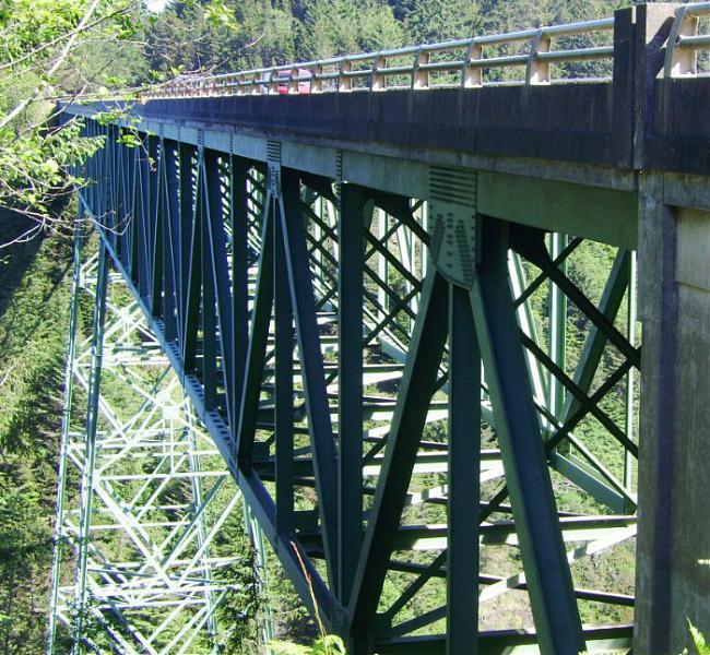
Oregon's highest [345ft] bridge is above Bosley Creek where it meets the breaking waves of the Pacific Ocean. There are parking areas on both sides of the bridge, with the south lot being larger and safer to pull out of. Surrounding coast is part of Samuel H. Boardman State Park.
Wikipedia article: http://en.wikipedia.org/wiki/Thomas_Creek_Bridge
Nearby cities:
Coordinates: 42°9'56"N 124°21'32"W
- Crescent City Harbor Breakwater 49 km
- Fern Canyon 88 km
- Carl G. Washburne Memorial State Park 224 km
- Devils Lake 317 km
- Cascade Head 324 km
- Nehalem Bay State Park 396 km
- Nehalem Bay 396 km
- Fort Stevens Historic Area 451 km
- Old Route of Penstock 699 km
- Carmanah Walbran Provincial Park 736 km
- Samuel H. Boardman State Scenic Corridor 0.6 km
- Harbor, Oregon 17 km
- Cape Sebastian State Scenic Corridor 19 km
- Chestnut Creek 32 km
- Otter Point State Recreation Site 33 km
- Agness, Oregon 50 km
- Humbug Mountain State Park 59 km
- Cape Blanco State Park 76 km
- Denmark, Oregon 82 km
- Bandon Dunes State Park 99 km
Comments