Tubo
Philippines /
Cordillera /
Besao /
World
/ Philippines
/ Cordillera
/ Besao
World / Philippines / Abra / Tubo
town, municipality, third-level administrative division
Municipality of Tubo, Province of Abra
ZIP code: 2814
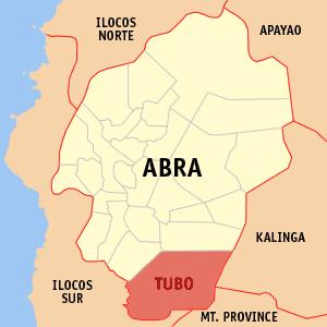
Tubo is a municipality in the landlocked province of Abra in the Philippines. It had a population of 5,719 people as registered in the 2010 Census.
The town is situated on the southern tip of the province, and is bounded by Mountain Province in the northeast, Ilocos Sur in the southeast, and the municipalities of Luba and Boliney on the west.
More or less 55 kilometers from Bangued, the capital of the province, this far flung municipality found in the southeasternmost part of Abra can be reached through various routes. Coming from Bangued, the place can be reached by passing through the towns of Penarrubia-Bucay-Manabo and Luba. It could also be reached via Candon-San Emilio and Tagudin-Quirino of the nearby province of Ilocos Sur.
Tubo is administratively subdivided into 10 barangays:
-Alangtin
-Amtuagan
-Dilong
-Kili
-Poblacion (Mayabo)
-Supo
-Tiempo
-Tubtuba
-Wayangan
-Tabacda
ZIP code: 2814
Tubo is a municipality in the landlocked province of Abra in the Philippines. It had a population of 5,719 people as registered in the 2010 Census.
The town is situated on the southern tip of the province, and is bounded by Mountain Province in the northeast, Ilocos Sur in the southeast, and the municipalities of Luba and Boliney on the west.
More or less 55 kilometers from Bangued, the capital of the province, this far flung municipality found in the southeasternmost part of Abra can be reached through various routes. Coming from Bangued, the place can be reached by passing through the towns of Penarrubia-Bucay-Manabo and Luba. It could also be reached via Candon-San Emilio and Tagudin-Quirino of the nearby province of Ilocos Sur.
Tubo is administratively subdivided into 10 barangays:
-Alangtin
-Amtuagan
-Dilong
-Kili
-Poblacion (Mayabo)
-Supo
-Tiempo
-Tubtuba
-Wayangan
-Tabacda
Wikipedia article: http://en.wikipedia.org/wiki/Tubo,_Abra
Nearby cities:
Coordinates: 17°15'16"N 120°48'55"E
- Conner 80 km
- Tineg 82 km
- Echague 99 km
- Kabugao 108 km
- Nueva Era 110 km
- Peñablanca 118 km
- San Mariano 124 km
- Lal-lo 135 km
- Dinapigue 140 km
- Calanasan 144 km
- BRGY.BAKLINGAYAN TUBO ABRA 3.5 km
- ano to? parang camp? 3.8 km
- Tagpeo Falls 8.4 km
- Mount Camingingel 10 km
- Mount Mengmeng 11 km
- Mount Sipitan 12 km
- Mount Lucotan 12 km
- LABAWAAN 13 km
- Mount Bangbalang 14 km
- Ilocos Sur 24 km
Comments