Beltsville Information Management Center "SA-26"
USA /
Maryland /
South Laurel /
Odell Road, 8601
World
/ USA
/ Maryland
/ South Laurel
World / United States / Maryland
Cold War 1947-1991, data center, federal government, satellite/space tracking station


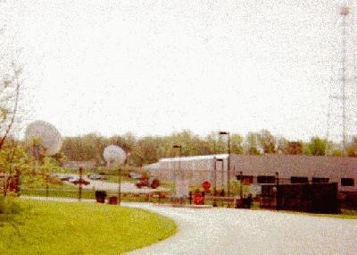

United States Department of State facility formerly named the Beltsville Communications Center and Beltsville Communications Annex
8601 Odell Road
Laurel, Maryland 20708
8601 Odell Road
Laurel, Maryland 20708
Wikipedia article: http://en.wikipedia.org/wiki/Beltsville_Messaging_Center
Nearby cities:
Coordinates: 39°2'46"N 76°51'50"W
- James J. Rowley Training Center 1.3 km
- Federal Law Enforcement Training Center 32 km
- Fort Belvoir - North Post 43 km
- Fort Belvoir - South Post 45 km
- Carroll Island (former chemical weapons test site) 55 km
- Warrenton Training Center. Station C 99 km
- FAA Mike Monroney Aeronautical Center 1880 km
- BLM 2378 km
- Bonneville Power Administration Ross Complex 3786 km
- Lompoc Federal Correctional Complex 3881 km
- Montpelier, Maryland 1.9 km
- Henry A. Wallace Beltsville Agricultural Research Center (BARC) 2.3 km
- Beltsville, Maryland 4.9 km
- Konterra, Maryland 5.4 km
- Maryland City, Maryland 6.8 km
- West Laurel, Maryland 7 km
- Patuxent Research Refuge 7.6 km
- Anne Arundel County, Maryland 23 km
- Prince George's County, Maryland 24 km
- Montgomery County, Maryland 32 km
Comments