Shahrasti Upazila HQ
Bangladesh /
Chandpur /
Hajiganj /
World
/ Bangladesh
/ Chandpur
/ Hajiganj
World / Bangladesh / Chittagong / Comilla / Chandpur
city
Add category
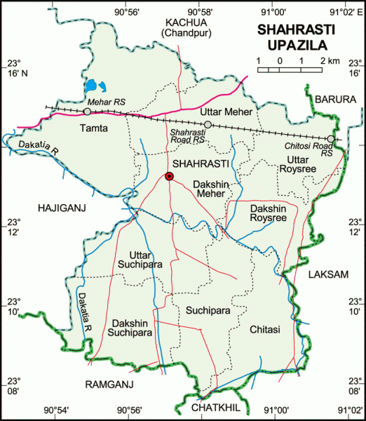
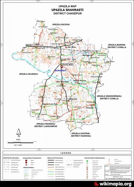
Shahrasti Upazila (Chandpur district) with an area of 154.31 sq km, is bounded by Kachua (Chandpur) upazila on the north, Chatkhil and Ramganj upazilas on the south, Laksham and Barura upazilas on the east and Hajiganj upazila on the west. Main river is Dakatia; noted canal is Shalakhali Khal.
The location of Shahrasti town is 23.2222N 90.95E. Shahrasti (Town) consists of 9 wards and 14 mahallas. The area of the town is 6.27 sq km. It has a population of 24374; male 49.63%, female 50.37%; population density per sq km is 3887. Literacy rate among the town people is 47.3%. The town has one dakbungalow.
Shahrasti thana was established in 1978 and was turned into an upazila in 1983. The upazila consists of one municipality, 9 union parishads, 162 mouzas and 176 villages.
As of the 1991 Bangladesh census: Population 180643; male 48.59%, female 51.41%; Muslim 95.12%, Hindu 4.84% and others 0.04%.
Religious institutions: Mosque 300, temple 5, tomb 1 and sacred place 1.
Literacy and educational institutions: Average literacy 43%; male 46.4% and female 39.8%. Educational institutions: college 4, high school 29, madrasa 15, government primary school 70, non-government primary school 18. Noted educational institutions: Chengachal Government Primary School (1913), Waruk Rahmania High School (1899), Dhamra High School (1913), Nunia Islamia Senior Madrasa (1931).
Cultural organisations: Rural club 23, library 1, cinema hall 1, playground 34.
Main occupations: Agriculture 33.32%, agricultural labourer 20.81%, wage labourer 2.93%, commerce 10.41%, service 16.83%, transport 2.25% and others 13.45%.
Land use: Total cultivable land 12164.31 hectares; single crop 20%, double crop 70% and treble crop land 10%; land under irrigation 80%.
Land control: Among the peasants, 14.49% are landless, 45.45% marginal, 27.36% small, 12.11% intermediate and 0.59% rich; cultivable land per head 0.07 hectare.
Fisheries, dairies, poultries Poultry 49, fishery 12, dairy 5 and hatchery 2.
Communication facilities- Roads: pucca 32 km, semi pucca 22 km and mud road 416 km; railways 20 km; waterways 8 nautical mile.
Cottage industries: Goldsmith 140, blacksmith 22, potteries 7, wood work 558, tailoring 402, bamboo work 135, welding 25 and cocoon production by female labour.
NGO activities: Operationally important NGOs are brac, asa, grameen bank, Helen Keller and Base.
Health centres: Upazila health complex 1, sub health centre 2, family planning centre 9.
Nearby cities:
Coordinates: 23°13'58"N 90°56'58"E
- Village Banglaish 7.8 km
- Garimondol Village, Chitoshi 8.7 km
- Sampur viLLege 11 km
- Sharifpur, Monohorgong, Comilla 11 km
- Hirapur viLLage 13 km
- NOLCHARA(PANCHRUKHI) 14 km
- vadur 16 km
- Monohorganj Upazila HQ 16 km
- THANAR HAT 17 km
- PORAN PUR BORO BHUIYAN BARI 19 km