The Peninsula at Bayonne Harbor (Bayonne, New Jersey)
USA /
New Jersey /
Bayonne /
Bayonne, New Jersey
World
/ USA
/ New Jersey
/ Bayonne
World / United States / New Jersey
park, closed / former military
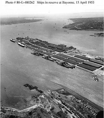
Formerly known as the Military Ocean Terminal at Bayonne (MOTBY), this facility opened in 1942 as an Annex of the Brooklyn Navy Yard and was intended to serve as both a heavy ship repair and warehousing facility for the US Navy for ships too large or tall to Navigate the East River and fit under the Brooklyn Bridge. When completed and commissioned, the port and warehouse complex had ten Northside (N1 through N10), seven Southside (S1 through S7) and two East side (E1,E2) berths located around the terminal peninsula. Several thousand square feet of secure enclosed warehouse space and the requisite rail and road facilities rounded out the base which at its peak employed about 3,000 civilian and US armed services personnel, handled more than 1 million tons of cargo each year and supplied ships for every major US military operation from World War II to the Persian Gulf in the 1990's.
Reassigned to US Army control in 1967, the wharves of MOTBY became a storage point for decommissioned deep-draft US Navy ships, including for a time several Aircraft Carriers, Battleships and Heavy Cruisers while the drydock and ship repair facility remained very active serving ships of the US Atlantic Fleet. With the collapse of the Soviet Union in 1993 the base came under review of the Base Realignment and Closure Commission (BRAC), which despite strong opposition from local, state, and federal officials voted to close MOTBY in 1995 and began the phase out of the nearly 2500 Army uniformed and civilian employees at the base. After 57 years in operation, the Military Ocean Terminal officially decommissioned and closed on September 23rd, 1999 and the land was returned to the City of Bayonne.
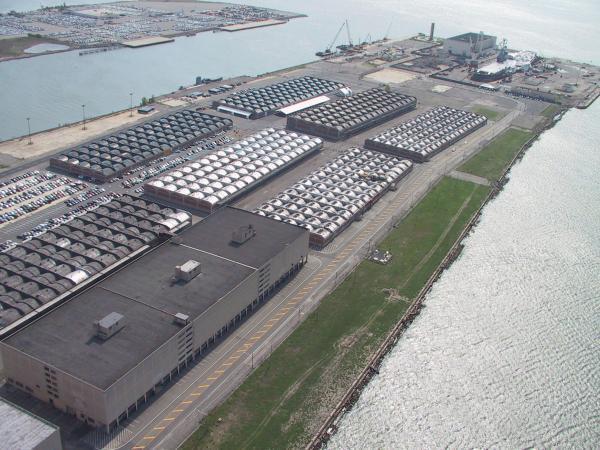
The land and buildings of the former terminal came under the stewardship of the Bayonne Local Redevelopment Authority (BLRA) and after officially renaming the land The Peninsula at Bayonne Harbor in April 2002 began an ambitious project to convert the former military facility into a mix-used waterfront community of residential, light industrial, commercial, and recreational space. The drydock facility was purchased in 2002 and now operates as the Bayonne Dry Dock & Repair Corp, and roughly half of the land has been re-zoned for maritime industrial trades, the most prominent of which is the Cape Liberty Cruise Port which opened in May 2004. Much of the remaining warehouse space has been razed for redevelopment into residential and commercial property.
www.bayonnelra.com/
www.greatsitkin.org/bayonne.html
Reassigned to US Army control in 1967, the wharves of MOTBY became a storage point for decommissioned deep-draft US Navy ships, including for a time several Aircraft Carriers, Battleships and Heavy Cruisers while the drydock and ship repair facility remained very active serving ships of the US Atlantic Fleet. With the collapse of the Soviet Union in 1993 the base came under review of the Base Realignment and Closure Commission (BRAC), which despite strong opposition from local, state, and federal officials voted to close MOTBY in 1995 and began the phase out of the nearly 2500 Army uniformed and civilian employees at the base. After 57 years in operation, the Military Ocean Terminal officially decommissioned and closed on September 23rd, 1999 and the land was returned to the City of Bayonne.
The land and buildings of the former terminal came under the stewardship of the Bayonne Local Redevelopment Authority (BLRA) and after officially renaming the land The Peninsula at Bayonne Harbor in April 2002 began an ambitious project to convert the former military facility into a mix-used waterfront community of residential, light industrial, commercial, and recreational space. The drydock facility was purchased in 2002 and now operates as the Bayonne Dry Dock & Repair Corp, and roughly half of the land has been re-zoned for maritime industrial trades, the most prominent of which is the Cape Liberty Cruise Port which opened in May 2004. Much of the remaining warehouse space has been razed for redevelopment into residential and commercial property.
www.bayonnelra.com/
www.greatsitkin.org/bayonne.html
Wikipedia article: http://en.wikipedia.org/wiki/Military_Ocean_Terminal_at_Bayonne
Nearby cities:
Coordinates: 40°40'8"N 74°5'15"W
- Liberty State Park 5 km
- High Rock Park 8.6 km
- La Tourette Park 11 km
- Great Kills Park 13 km
- Marine Park 14 km
- Barren Island 16 km
- Floyd Bennett Field (NOP) 17 km
- Spring Creek Park / Spring Creek Park Addition 18 km
- Fort Tilden Park 19 km
- Forest Park 19 km
- Bayonne Auto Terminal 0.4 km
- Global Container Terminal Bayonne 0.9 km
- Bayonne Golf Club 1 km
- International Matex Tank Terminal (IMTT) Bayonne 2.1 km
- St. George (Staten Island, NY) 3 km
- Upper New York Bay 3 km
- West New Brighton (Staten Island, New York) 3.7 km
- Hudson County, New Jersey 7.2 km
- Brooklyn 12 km
- Staten Island 13 km