Sreenagar Upazila HQ
Bangladesh /
Munshiganj /
World
/ Bangladesh
/ Munshiganj
/ Munshiganj
World / Bangladesh / Dhaka / Dhaka / Munshigonj
city
Add category
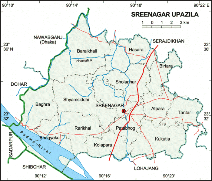
Sreenagar Upazila (Munshiganj district) with an area of 202.98 sq km, is bounded by Keraniganj and Nawabganj (Dhaka) upazilas on the north, Lohajang and Shibchar upazilas on the south, Serajdikhan and Lohajang upazilas on the east, Nawabganj, Dohar and Sadarpur upazilas on the west. Main rivers are Padma and Ichamati; Arial beel is notable.
The location of Sreenagar town is 23.5406718N 90.2863771E. Sreenagar (Town) consists of two mouzas. The area of the town is 1.99 sq km. It has a population of 9244; male 56.51% and female 43.49%. Literacy rate among the town people is 49.5%.
Sreenagar thana was turned into an upazila in 1983. It consists of 14 union parishads, 102 mouzas and 147 villages.
As of the 1991 Bangladesh census, Population 205797; male 49.87%, female 50.13%; Muslim 87.61%, Hindu 12.34%, others 0.05%.
Religious institutions Mosque 247, temple 53.
Literacy and educational institutions Average literacy 38.56%; male 42.04%, female 35.09%. Educational institutions: college 4, high school 22, government primary school 92, non-government primary school 11, madrasa 31, orphanage 1.
Main occupations Agriculture 24.66%, agricultural labourer 18.97%, wage labourer 2.03%, weaving 1.35%, construction 1.86%, fishing 2.34%, commerce 22.66%, service 10.61%, others 15.52%.
Land use Cultivable land 15285 hectares, fallow land 5985 hectares; single crop 52.74%, double crop 38.74% and triple crop land 8.52%.
Land control Among the peasants, 19% landless, 35% small, 28% intermediate and 18% rich; cultivable land per head 0.074 hectare.
Fisheries, poultries and dairies Fishery 683, poultry 135, dairy 192, hatchery 1.
Communication facilities Roads: pucca 98 km, semi pucca 11 km and mud road 155 km, waterways 9 nautical mile.
Manufactories Dairy 2, rice mill 19, saw mill 27, cold storage 2, brick-field 4.
Cottage industries Welding workshop 28, carpenter 250, goldsmith 225, potteries 115, blacksmith 100.
NGO activities Operationally important NGOs are caritas, grameen bank, brac, asa.
Health centres Upazila health complex 1, satellite clinic 3, pathological laboratory 3, family planning centre 10, veterinary hospital 1
Nearby cities:
Coordinates: 23°32'33"N 90°17'26"E
- Arial Beel Area 5.6 km
- Lohajang Upazila 10 km
- Jazirah Union 23 km
- Bara Gopalpur Union 26 km
- Sadarpur Upazila HQ 29 km
- Cirnodi 36 km
- Bhanga Upazila HQ 36 km
- Madaripur 41 km
- Dhaka Division 67 km
- TROPIC OF CANCER 960 km
Comments