Shariatpur Dist. Town
Bangladesh /
Shariatpur /
Palang /
World
/ Bangladesh
/ Shariatpur
/ Palang
World / Bangladesh / Dhaka / Faridpur / Shariatpur
city
Add category
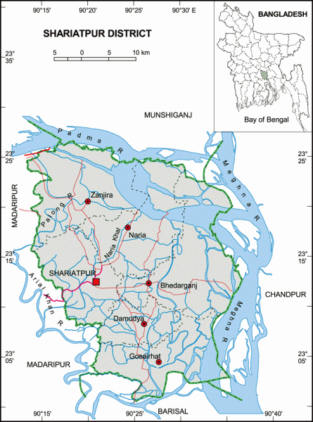

Shariatpur District (Dhaka division) with an area of 1181.53 sq km, is bounded by Munshiganj district on the north, Barisal district on the south, Chandpur district on the east, Madaripur district on the west. Annual average temperature: highest 35.8°C and lowest 12.6°C; annual rainfall 2105 mm. Main rivers are Padma, Meghna, Palong and Kirtinasha.
The location of Shariatpur town centre is 23.206084N 90.3473783E. Shariatpur (Town) a municipal town, consists of 9 wards and 26 mahallas. The area of the town is 25.5 sq km. The town has a population of 42154; male 51.55%, female 48.45%. The density of population is 1653 per sq km.
Shariatpur was named after Haji Shariatullah (1781–1840), who was the founder of Faraizi Movement and an eminent Islamic reformer during British Raj.
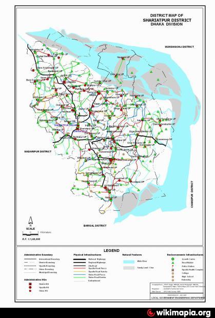
Shariatpur district was established on 1 March 1984. Earlier it was known as Palong thana under Madaripur sub-division which was converted to Shariatpur Sub-division and latterly a district with 6 upgraded thanas. It consists of 6 upazilas, 5 municipalities, 64 union parishads, 45 wards, 93 mahallas, 1230 villages and 607 mouzas. The upazilas are bhedarganj, damudya, gosairhat, naria, shariatpur sadar and zanjira.
Archaeological haritage: South Baluchara Mosque, Bilaskhan Mosque (Mughal period), Fatehjongpur Fort, Kedarbari at Kedarpur, Haturia and Kartikpur zamindarbaris, Mohishar dighi (pond) and Burirhat Mosque.
Religious institution: Mosque 1963, temple 57, tomb 3, Darbar Sharif 9.
As of the 1991 Bangladesh census, Population 1057181; male 49.58%, female 50.42%; Muslim 95.54%, Hindu 4.30% and others 0.16%.
Literacy and educational institutions: Average literacy 24.4%; male 30.3% and female 18.4%. Educational institutions: government college 2, non-government college 16, government high school 1, non-government high school 80, government primary school 396, non-government high school 121, madrasa 60, NGO operated schools 28, satellite school 40, community school 40, kindergarten 2, non-government medical college 1.
Cultural organisations: Cinema hall 10, public library 3, club 125, drama club 2, women's organisation 3, literary organisation 3.
Main occupations: Agriculture 46.53%, agricultural labourer 23.22%, fishing 1.29%, wage labourer 3.19%, commerce 9.55%, service 4.95%, others 11.27%.
Land use: Cultivable land 83805 hectares; single crop 22.24%, double crop 50.12% and treble crop land 27.64%.
Land control: Among the peasants, 22% are landless, 29% marginal, 28% small, 17% intermediary, 4% rich.
Fisheries, dairies and poultries Fishery 32, poultry 1453, dairy 56.
Communication facilities- Roads: pucca 174.09 km, semi pucca 99.64 km and mud road 2066.43 km; waterways 49 nautical mile.
Manufactories: Ice factory 13, saw mill 35, shoe factory 4, oil mill 6, rice mill 164, bidi factory 9.
Cottage industries Weaving 88, goldsmith 341, blacksmith 324, potteries 90, tailoring 425, welding 47.
NGO activities: Grameen Unnayan Sangstha, SDS, Madaripur Mahila Unnayan Sangstha, brac, asa, GUP, Madaripur Lagal Aid Association.
Health centres: Government hospital 1, upazila health complex 6, union health and family planning centre 33, charitable dispensary 5, maternity and child care centre 3.
The location of Shariatpur town centre is 23.206084N 90.3473783E. Shariatpur (Town) a municipal town, consists of 9 wards and 26 mahallas. The area of the town is 25.5 sq km. The town has a population of 42154; male 51.55%, female 48.45%. The density of population is 1653 per sq km.
Shariatpur was named after Haji Shariatullah (1781–1840), who was the founder of Faraizi Movement and an eminent Islamic reformer during British Raj.
Shariatpur district was established on 1 March 1984. Earlier it was known as Palong thana under Madaripur sub-division which was converted to Shariatpur Sub-division and latterly a district with 6 upgraded thanas. It consists of 6 upazilas, 5 municipalities, 64 union parishads, 45 wards, 93 mahallas, 1230 villages and 607 mouzas. The upazilas are bhedarganj, damudya, gosairhat, naria, shariatpur sadar and zanjira.
Archaeological haritage: South Baluchara Mosque, Bilaskhan Mosque (Mughal period), Fatehjongpur Fort, Kedarbari at Kedarpur, Haturia and Kartikpur zamindarbaris, Mohishar dighi (pond) and Burirhat Mosque.
Religious institution: Mosque 1963, temple 57, tomb 3, Darbar Sharif 9.
As of the 1991 Bangladesh census, Population 1057181; male 49.58%, female 50.42%; Muslim 95.54%, Hindu 4.30% and others 0.16%.
Literacy and educational institutions: Average literacy 24.4%; male 30.3% and female 18.4%. Educational institutions: government college 2, non-government college 16, government high school 1, non-government high school 80, government primary school 396, non-government high school 121, madrasa 60, NGO operated schools 28, satellite school 40, community school 40, kindergarten 2, non-government medical college 1.
Cultural organisations: Cinema hall 10, public library 3, club 125, drama club 2, women's organisation 3, literary organisation 3.
Main occupations: Agriculture 46.53%, agricultural labourer 23.22%, fishing 1.29%, wage labourer 3.19%, commerce 9.55%, service 4.95%, others 11.27%.
Land use: Cultivable land 83805 hectares; single crop 22.24%, double crop 50.12% and treble crop land 27.64%.
Land control: Among the peasants, 22% are landless, 29% marginal, 28% small, 17% intermediary, 4% rich.
Fisheries, dairies and poultries Fishery 32, poultry 1453, dairy 56.
Communication facilities- Roads: pucca 174.09 km, semi pucca 99.64 km and mud road 2066.43 km; waterways 49 nautical mile.
Manufactories: Ice factory 13, saw mill 35, shoe factory 4, oil mill 6, rice mill 164, bidi factory 9.
Cottage industries Weaving 88, goldsmith 341, blacksmith 324, potteries 90, tailoring 425, welding 47.
NGO activities: Grameen Unnayan Sangstha, SDS, Madaripur Mahila Unnayan Sangstha, brac, asa, GUP, Madaripur Lagal Aid Association.
Health centres: Government hospital 1, upazila health complex 6, union health and family planning centre 33, charitable dispensary 5, maternity and child care centre 3.
Nearby cities:
Coordinates: 23°12'32"N 90°20'49"E
- Angaria Bazar 3.1 km
- boro bari , sorder bari 5.4 km
- baher chor katla, jafrabaz 11 km
- lake ar kona area 15 km
- কলেজ রোড (college road) 15 km
- Puran Bazar, Madaripur 15 km
- Madaripur District Town 17 km
- Madaripur 17 km
- A.R.Howladar Jute Mills 17 km
- Dhaka Division 104 km