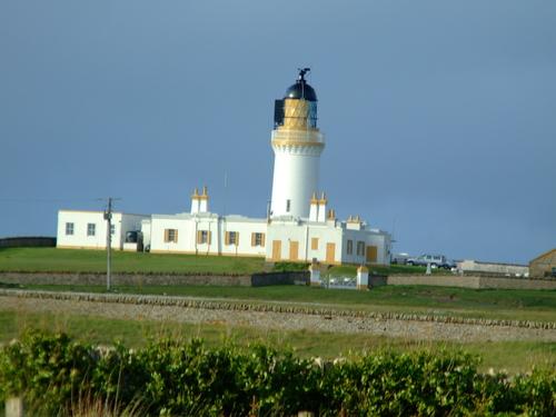
Noss Head Lighthouse
United Kingdom /
Scotland /
Wick /
World
/ United Kingdom
/ Scotland
/ Wick
World / United Kingdom / Scotland
lighthouse
Add category


Light Established 1849
Engineer Alan Stevenson
Builder Robert Arnot of Inverness
Position Latitude 50° 28.8'N Longitude 03° 03.0'W
Character Flashing white/red every 20 sec.
Nominal Range White 25m Red 21 miles
Structure White stone tower, 18 metres high.
History The lighthouse was completed in 1849 and the light was switched on Monday 18 June 1849. A new style of lantern with diagonal instead of vertical framing was first used by Stevenson at Noss Head. Stronger and less liable to intercept light in any particular direction, it was adopted as the standard pattern for the service. The lens which is approximately 6ft in diameter rotates by clockwork machinery around a mercury vapour lamp. An access road from Wick to Noss Head was bult by the unemployed poor of the area who were paid 3/6d per day.
The Light was automated in 1987 and is now remotely monitored from the Northern Lighthouse Board’s headquarters in Edinburgh.
www.scotlandsplaces.gov.uk/search_item/index.php?servic...
Nearby cities:
Coordinates: 58°28'44"N 3°3'3"W
- Cantick Head Lighthouse 35 km
- Calf of Cava and Lighthouse 46 km
- Cape Wrath Lighthouse 114 km
- Cape Wrath Firing Range 116 km
- Buchan Ness Lighthouse 135 km
- Butt of Lewis Lighthouse 187 km
- Bell Rock Lighthouse 231 km
- Ushinish Lighthouse 278 km
- St Abbs Head Lighthouse and Fog horn 291 km
- Thridrangar Lighthouse 1091 km
- Wick Airport, Former RAF Wick, 3.4 km
- Former RAF Skitten 6.8 km
- Loch Watten 16 km
- Duncansby Head 18 km
- Former RAF Castletown Caithness 21 km
- Stroma Island 23 km
- Bay 30 km
- South Ronaldsay 34 km
- South Walls part of Hoy 36 km
- Hoy 44 km