St.-Vaast-la-Hougue Lighthouse
France /
Basse-Normandie /
Saint-Vaast-la-Hougue /
World
/ France
/ Basse-Normandie
/ Saint-Vaast-la-Hougue
France / World / Basse-Normandie / Manche / Cherbourg / Sainte-Mère-Église
lighthouse
Add category
St.-Vaast-la-Hougue
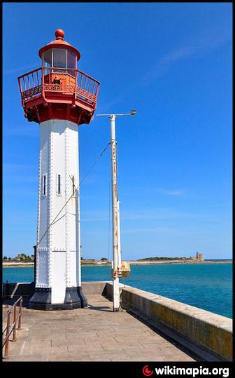
1865 (station established 1850). Active; focal plane 12 m (39 ft); white, red, or green light, depending on direction, occulting twice every 6 s. 11 m (36 ft) octagonal cylindrical cast iron tower with lantern and gallery. Fog siren (one long and one short blast every 30 s). Tower painted white, lantern and gallery red. Guyomard and Carceller have the photo at right and other good photos, Trabas has a photo by Arno Siering, and Huelse has a historic postcard view. This is one of many cast iron tourelles prefabricated by the firm of Sautter et Lemonnier. Apparently this is the oldest survivor of its class, since the first one built, for Calais Jetée de l'Est, was swept away by a storm. Located on the end of the jetty of the new harbor of St.-Vaast-la-Hougue, on the east side of town facing l'Île de Tatihou. Accessible by walking the jetty. Site open, tower closed. ARLHS FRA-151
1865 (station established 1850). Active; focal plane 12 m (39 ft); white, red, or green light, depending on direction, occulting twice every 6 s. 11 m (36 ft) octagonal cylindrical cast iron tower with lantern and gallery. Fog siren (one long and one short blast every 30 s). Tower painted white, lantern and gallery red. Guyomard and Carceller have the photo at right and other good photos, Trabas has a photo by Arno Siering, and Huelse has a historic postcard view. This is one of many cast iron tourelles prefabricated by the firm of Sautter et Lemonnier. Apparently this is the oldest survivor of its class, since the first one built, for Calais Jetée de l'Est, was swept away by a storm. Located on the end of the jetty of the new harbor of St.-Vaast-la-Hougue, on the east side of town facing l'Île de Tatihou. Accessible by walking the jetty. Site open, tower closed. ARLHS FRA-151
Nearby cities:
Coordinates: 49°35'10"N 1°15'24"W
- Casquets triple Lighthouses 82 km
- Nab Tower 122 km
- Saint Albans Light House 123 km
- Channel Light Vessel Automatic 125 km
- No Mans Land Fort Light 129 km
- Horse Sand Fort Light 130 km
- Eddystone Lighthouse 226 km
- Mumbles Lighthouse 292 km
- Great Castle Head Lighthouse 361 km
- St. Ann's Head Lighthouse 362 km
- Port of St. Vaast-la-Hougue 0.6 km
- Ile de Tatihou 1 km
- Oyster farms 2.2 km
- Jonville beach 2.8 km
- Wreck of USS YMS-304 4.4 km
- Fontenay-sur-Mer 11 km
- Saint-Germain-de-Tournebut 12 km
- Saint-Marcouf 12 km
- Saint-Floxel 13 km
- Montebourg 14 km