Satkhira District Town
Bangladesh /
Satkhira /
World
/ Bangladesh
/ Satkhira
/ Satkhira
third-level administrative division, town district
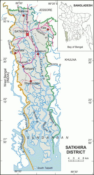
Satkhira District (Khulna division) with an area of 3858.33 sq km, is a south west bordered district of Bangladesh. It is bounded by Jessore district on the north, the bay of Bengal on the south, Khulna district on the east, Pargana district of West Bengal on the west. Annual average temperature is maximum 35.5°C, minimum 12.5°C; annual rainfall 1710 mm. The soil of the district is alluvial floodplain. Main rivers are Kobadak, Sonai, Kholpatua, Morischap, Raimangal, Hariabhanga, ichamati, Betrabati and Kalindi-jamuna.
Satkhira, a municipal town, consists of 9 wards and 31 mahallas. The area of the town is 27.84 sq km. The town has a population of 86372; male 51.75%, female 48.25%; population density per sq km 3102. Literacy rate among the town people is 49.7%. The main business centre of the town is Sultanpur Bazar (old name Pransayar Bazar).
The geographic location of the Satkhira Town centre is 22.7185622N 89.0696597E.
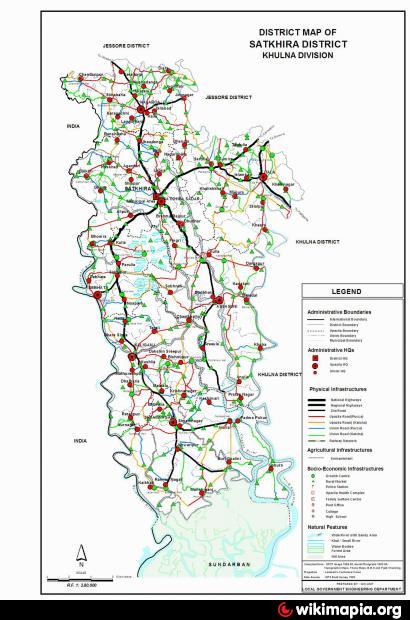
Satkhira subdivision was established in 1861 under Jessore district. It was included into Khulna district in 1882. The subdivision was turned into a district in 1984. The district consists of 2 municipalities, 18 wards, 41 mahallas, 7 upazilas, 79 union parishads, 953 mouzas and 1436 villages. The upazilas are satkhira sadar, assasuni, debhata, kalaroa, kaliganj, shyamnagar and tala; the municipalities are Satkhira Sadar and Kalaroa.
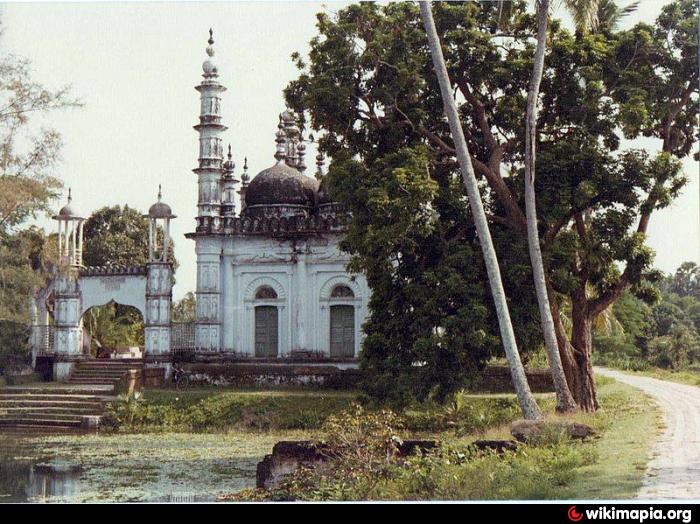
Archaeological heritage and relics: The region is home to many ancient buildings and temples such as Sultanpur Shahi Mosque (500 years old), Joykali Mandir, Puratan Satkhira (300 years old), Jahajghata Naval Fort (Mautala, 1567), Baro Duary (Ishwaripur, 1582), Shahi Mosque (Banshipur, 1599), Joseshwari Mandir (Ishwaripur, 1899), Triangular Mandir of Chanda Bhairabi (Ishwaripur),Mothbaria Nabaratna Mandir (sonabaria, kalaroa 1767), Nagar Fort of Raja Pratapaditya (Kaliganj), Parabajpur Mosque (Mukundapur), Hamman Khana (Ishwaripur), the Mozaffar Garden, the Tetulia Jami Mosque (Tala, 1858–59).
Historical events: In 1781, most of the areas of Jessore, Faridpur and Khulna were brought under a single administration. But later on while peasant movement spread over the region against the oppressions of indigo planters and the local zamindars, the British established a subdivision at Satgharia under Jessore district to control indigo revolt and to strengthen local administration. Satgharia turned into 'Satkhira' in the records of the British. Satkhira region was a part of the ancient Vanga janapada. Once it was the capital of the state of Bara-bhuiyan of Bengal. Peasant movement, against the East India Company and oppressions of the local zamindars spread over the district in 1801 under the leadership of Titumir. Besides, indigo resistance movement and Wahabi movement spread over the district during 1854 to 1860.
Religious institutions: Mosque 2124, temple 247, church 12, tomb 27 and sacred place 2.
As of the 1991 Bangladesh census, Population 1843194; male 50.54%, female 49.46%; Muslim 78.08%; Hindu 21.45%, Christian 0.28%, Buddhist 0.01% and others 0.18%. Ethnic nationals: 0.09% of the total population (Mundari (Buno) and Santal). They have their own language.
Literacy and educational institutions: Average literacy 30.35%; male 39.7% and female 21%.
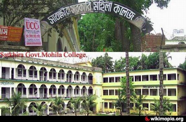
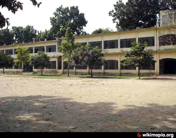
Educational institutions: college 39, primary education institute 1, high school 221, junior high school 4, madrasa 259, government primary school 622, non-government primary school 362, survey institute 1, nursing institute 1, vocational institute 1, law college 1, technical educational institution 6, low cost primary school 12, satellite school 5, retarded school 1, kindergarten 13, art school 8, music school 11. Noted educational institutions: PNP Collegiate School (1846), Prananath High School (1862), BD School (Tala, 1887), Babulia Joymoni Shreenath Institution (1883), Khalishkhali Magura School (1899), Nakipur Haricharan High School ((1899), Kumira Multilateral High School (1914), Town Shreepur Sharatchandra High School (1916), Nalta High School (1917), Assasuni High School (1911), Debhata BBMP Institute (Pilot High School, 1919), Dhandia High School (Kalaroa, 1885), Kaliganj High School (1936).
Cultural organisations: Club 307, public library 16, cinema hall 15, literary society 17, theatre group 20, theatre stage 1, opera party 32, circus party 2, women's organisation 91, playground 93, community centre 1, shilpakala academy 1.
Main occupations: Agriculture 36.9%, fishing 1.86%, pisciculture 1.01%, agricultural labourer 26.74%, wage labourer 3.72%, commerce 13.32%, industry 1.49%, transport 2.46%, service 4.37%, and others 8.13%.
Land use: Total cultivable land 140953.93 hectares, fallow land 41220.31 hectares; single crop 46.91%, double crop 42.19% and treble crop land 10.90%; cultivable land under irrigation 34.03%.
Land control: Among the peasants, 18.40% are landless, 33.62% small, 24.55% intermediate and 23.43% rich; cultivable land per head 0.09 hectare.
Fisheries, dairies, poultries Poultry 322, dairy 86, fishery 3046, shrimp farming 3650, hatchery 66, artificial breeding centre 1.
Communication facilities- Roads: pucca 335 km, semi pucca 276 km and mud road 3580 km; waterways 164 nautical mile.
Manufactories: Textile mills, rice mill, ice factory, flour mill, oil mill, biscuit factory, fish processing factory, cold storage, saw mill, lathe machine, printing press, welding.
Cottage industries: Satkhira is famous for weaving, bamboo and cane work and potteries; other cottage industries include goldsmith, blacksmith, potteries, wood work, mat work, tailoring, date molasses and jute and cotton work.
NGO activities: Operationally important NGOs are brac, CARE, World Vision, caritas, grameen bank, asa, Barsa, Chetana, Swadesh, Uttaran, Pragati, Usha, Parapar, Jubo Academy Satkhira, Seeds, etc.
Health centres: Zila sadar hospital 1, upazila health complex 7, child hospital 1, TB hospital 1, health and family welfare centre 66, private hospital 1, government clinic 2, private clinic 3, maternity and child welfare centre 1.
Sundarbans is the largest single block of tidal halophytic mangrove forest in the world and is a World Heritage Site, and covers an area of 5747 km².
Satkhira, a municipal town, consists of 9 wards and 31 mahallas. The area of the town is 27.84 sq km. The town has a population of 86372; male 51.75%, female 48.25%; population density per sq km 3102. Literacy rate among the town people is 49.7%. The main business centre of the town is Sultanpur Bazar (old name Pransayar Bazar).
The geographic location of the Satkhira Town centre is 22.7185622N 89.0696597E.
Satkhira subdivision was established in 1861 under Jessore district. It was included into Khulna district in 1882. The subdivision was turned into a district in 1984. The district consists of 2 municipalities, 18 wards, 41 mahallas, 7 upazilas, 79 union parishads, 953 mouzas and 1436 villages. The upazilas are satkhira sadar, assasuni, debhata, kalaroa, kaliganj, shyamnagar and tala; the municipalities are Satkhira Sadar and Kalaroa.
Archaeological heritage and relics: The region is home to many ancient buildings and temples such as Sultanpur Shahi Mosque (500 years old), Joykali Mandir, Puratan Satkhira (300 years old), Jahajghata Naval Fort (Mautala, 1567), Baro Duary (Ishwaripur, 1582), Shahi Mosque (Banshipur, 1599), Joseshwari Mandir (Ishwaripur, 1899), Triangular Mandir of Chanda Bhairabi (Ishwaripur),Mothbaria Nabaratna Mandir (sonabaria, kalaroa 1767), Nagar Fort of Raja Pratapaditya (Kaliganj), Parabajpur Mosque (Mukundapur), Hamman Khana (Ishwaripur), the Mozaffar Garden, the Tetulia Jami Mosque (Tala, 1858–59).
Historical events: In 1781, most of the areas of Jessore, Faridpur and Khulna were brought under a single administration. But later on while peasant movement spread over the region against the oppressions of indigo planters and the local zamindars, the British established a subdivision at Satgharia under Jessore district to control indigo revolt and to strengthen local administration. Satgharia turned into 'Satkhira' in the records of the British. Satkhira region was a part of the ancient Vanga janapada. Once it was the capital of the state of Bara-bhuiyan of Bengal. Peasant movement, against the East India Company and oppressions of the local zamindars spread over the district in 1801 under the leadership of Titumir. Besides, indigo resistance movement and Wahabi movement spread over the district during 1854 to 1860.
Religious institutions: Mosque 2124, temple 247, church 12, tomb 27 and sacred place 2.
As of the 1991 Bangladesh census, Population 1843194; male 50.54%, female 49.46%; Muslim 78.08%; Hindu 21.45%, Christian 0.28%, Buddhist 0.01% and others 0.18%. Ethnic nationals: 0.09% of the total population (Mundari (Buno) and Santal). They have their own language.
Literacy and educational institutions: Average literacy 30.35%; male 39.7% and female 21%.
Educational institutions: college 39, primary education institute 1, high school 221, junior high school 4, madrasa 259, government primary school 622, non-government primary school 362, survey institute 1, nursing institute 1, vocational institute 1, law college 1, technical educational institution 6, low cost primary school 12, satellite school 5, retarded school 1, kindergarten 13, art school 8, music school 11. Noted educational institutions: PNP Collegiate School (1846), Prananath High School (1862), BD School (Tala, 1887), Babulia Joymoni Shreenath Institution (1883), Khalishkhali Magura School (1899), Nakipur Haricharan High School ((1899), Kumira Multilateral High School (1914), Town Shreepur Sharatchandra High School (1916), Nalta High School (1917), Assasuni High School (1911), Debhata BBMP Institute (Pilot High School, 1919), Dhandia High School (Kalaroa, 1885), Kaliganj High School (1936).
Cultural organisations: Club 307, public library 16, cinema hall 15, literary society 17, theatre group 20, theatre stage 1, opera party 32, circus party 2, women's organisation 91, playground 93, community centre 1, shilpakala academy 1.
Main occupations: Agriculture 36.9%, fishing 1.86%, pisciculture 1.01%, agricultural labourer 26.74%, wage labourer 3.72%, commerce 13.32%, industry 1.49%, transport 2.46%, service 4.37%, and others 8.13%.
Land use: Total cultivable land 140953.93 hectares, fallow land 41220.31 hectares; single crop 46.91%, double crop 42.19% and treble crop land 10.90%; cultivable land under irrigation 34.03%.
Land control: Among the peasants, 18.40% are landless, 33.62% small, 24.55% intermediate and 23.43% rich; cultivable land per head 0.09 hectare.
Fisheries, dairies, poultries Poultry 322, dairy 86, fishery 3046, shrimp farming 3650, hatchery 66, artificial breeding centre 1.
Communication facilities- Roads: pucca 335 km, semi pucca 276 km and mud road 3580 km; waterways 164 nautical mile.
Manufactories: Textile mills, rice mill, ice factory, flour mill, oil mill, biscuit factory, fish processing factory, cold storage, saw mill, lathe machine, printing press, welding.
Cottage industries: Satkhira is famous for weaving, bamboo and cane work and potteries; other cottage industries include goldsmith, blacksmith, potteries, wood work, mat work, tailoring, date molasses and jute and cotton work.
NGO activities: Operationally important NGOs are brac, CARE, World Vision, caritas, grameen bank, asa, Barsa, Chetana, Swadesh, Uttaran, Pragati, Usha, Parapar, Jubo Academy Satkhira, Seeds, etc.
Health centres: Zila sadar hospital 1, upazila health complex 7, child hospital 1, TB hospital 1, health and family welfare centre 66, private hospital 1, government clinic 2, private clinic 3, maternity and child welfare centre 1.
Sundarbans is the largest single block of tidal halophytic mangrove forest in the world and is a World Heritage Site, and covers an area of 5747 km².
Wikipedia article: http://en.wikipedia.org/wiki/Satkhira_District
Nearby cities:
Coordinates: 22°43'1"N 89°4'23"E
- Chuadanga District 132 km
- Meherpur District 150 km
- Patran Tehsil 1545 km
- Bicholim Taluka 1776 km
- Pedne Taluka 1789 km
- Bardez Taluka 1791 km
- Tehsil Kallar Syedan 1961 km
- Garadagh district 4212 km
- Tegh Region 4439 km
- Meghri Municipality 4443 km
- TALA 4.6 km
- CHELAR BILL..(TANU) 7.4 km
- DHEKUR BILL 8.6 km
- Kalaroa Upazila HQ 16 km
- Bill Balli 20 km
- Uludanga 21 km
- Uludanga 21 km
- Tala Upazila HQ 23 km
- Mongolkote, Keshebpur 24 km
- Khulna Division 34 km