Mapodaegyo (Yeongdeungpo-gu)
Korea (South) /
Soul /
Seoul /
Yeongdeungpo-gu /
Yeouido-dong
World
/ Korea (South)
/ Soul
/ Seoul
World / South Korea / Seoul
bridge
Add category
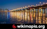
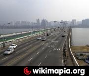
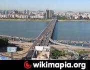
The Mapo Bridge (Korean: 마포대교) crosses the Han River in South Korea and connects the Mapo District and the Yeongdeungpo District in the city of Seoul. The bridge was completed in 1970. Until 1984, the bridge was called Seoul Bridge.
Wikipedia article: http://en.wikipedia.org/wiki/Mapo_Bridge
Nearby cities:
Coordinates: 37°31'59"N 126°56'9"E
- Wonhyodaegyo 0.4 km
- Donghodaegyo 7.2 km
- Haengchu Bridge 14 km
- 김포대교 Gimpo Bridge 16 km
- Ilsan bridge 24 km
- Sinyangsudaegyo 33 km
- Yeongjong Bridge 35 km
- Yongdamdaegyo 36 km
- Incheon Grand Bridge 38 km
- Seohaedaegyo 65 km
- Yeouido-dong 0.9 km
- Bamseom 0.9 km
- Yeouido Hangang Park (Han River Park) 1 km
- Yonggang-dong 1 km
- Yeouido Park 1.4 km
- Sinsu-dong 1.7 km
- Dangin-dong 1.8 km
- The National Assembly of the Republic of Korea 1.8 km
- Sangsu-dong 1.9 km
- Hapjeong-dong 3 km