Vista Point (Hwy 74, Riverside County)
USA /
California /
Alpine Village /
World
/ USA
/ California
/ Alpine Village
World / United States / California
mountain, hill, scenic lookout, interesting place


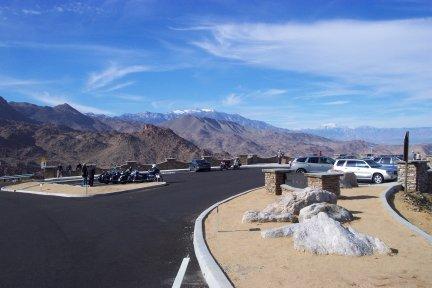

a turnout/viewpoint area created and opened to general traffic around 1970, as a result of road crews needing storage for debris during severe winter storms of the previous few years.
Vista Point is about five miles up Hwy 74 as it snakes its way out of the Coachella Valley south of Palm Desert and into the Santa Rosa Mountains. Offers great views of Bighorn Country Club, and views north and east of Palm Desert, Indian Wells, and La Quinta, awesome views of the San Jacinto and San Gorgonio mountains, and on a nice clear day (like after a rain/snow storm) you can see the north tip of the Salton Sea about forty miles away to the southeast.
Was a favored parking/goof-off spot for years of Coachella Valley inhabitants, and of course many travelers. Used to be just a paved flat lot jutting off the top of a canyon, in 2008 it was re-paved, had sidewalks and guardrails added and a few decorative plaques and other things added to spruce it up. Still very heavily visited by travelers of Hwy 74.
Nearby cities:
Coordinates: 33°38'57"N 116°24'2"W
- Mecca Hills Wilderness Area (BLM) 30 km
- Newberry Mountains Wildernesss Area 137 km
- Chino Hills State Park 138 km
- Riverside Mountains Wilderness Area 169 km
- Wellton Hills 237 km
- Alabama Hills 372 km
- Burbank Hills 630 km
- Los Medanos Hills/Pittsburg Hills 705 km
- Montezuma Hills 708 km
- Sutter Buttes 798 km
- The Reserve Golf Course 5.4 km
- Pinyon Crest 5.8 km
- The Living Desert Zoo and Gardens 6.6 km
- Piñon Flats Observatory (PFO) 6.8 km
- Coachella Valley 12 km
- San Bernardino National Forest 18 km
- Rockhouse Canyon 24 km
- Anza, California 28 km
- Mountain Center 31 km
- Cahuilla Indian Reservation 32 km