Probuschdenie
Russia /
Omsk /
Isilkul /
World
/ Russia
/ Omsk
/ Isilkul
, 31 km vom Zentrum (Исилькуль)
Världen / Russland / Oblast de Omsk
Trakt
Kategorie hinzufügen
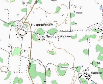

Das ehemaliges Dorf Probuschdenie. Das Dorf wird zum ersten Mal auf der Karte von 1928 angegeben.
www.etomesto.ru/map-omsk_1928-okrug/?x=71.563417&y=54.8...
www.etomesto.ru/map-omsk_genshtab/?x=71.546252&y=54.859...
www.etomesto.ru/map-atlas_topo-5km/?x=71.546252&y=54.85...
www.etomesto.ru/map-genshtab_n-42/?x=71.546252&y=54.859...
www.etomesto.ru/map-atlas_topo-russia-ural/?x=71.546252...
www.etomesto.ru/map-omsk_topographic-map/?x=71.546252&y...
www.etomesto.ru/map-kazakhstan_topo/?x=71.546252&y=54.8...
www.etomesto.ru/map-omsk_topokarta-1km/?x=71.554492&y=5...
Nearby cities:
Koordinaten: 54°51'30"N 71°32'53"E
- Krasnyj Borok (Alexejewka) 3.6 km
- Friedhof Krasnyj Borok (Alexejewka) 4 km
- Krasnyj Borok (Alexejewka) 4.1 km
- Friedhof Rosowka 4.8 km