Probuzhdeniye
Russia /
Omsk /
Isilkul /
World
/ Russia
/ Omsk
/ Isilkul
, 31 km from center (Исилькуль)
World / Russia / Omsk
urochishte (stow)
Add category
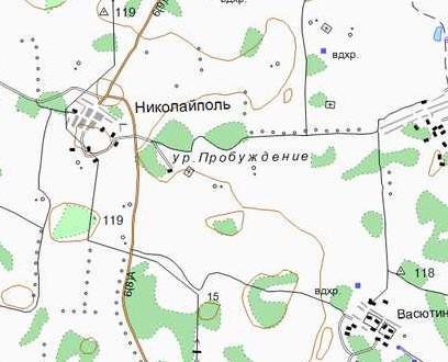

The former village of Probuzhdeniye. The village is indicated for the first time on the map from 1928.
www.etomesto.ru/map-omsk_1928-okrug/?x=71.563417&y=54.8...
www.etomesto.ru/map-omsk_genshtab/?x=71.546252&y=54.859...
www.etomesto.ru/map-atlas_topo-5km/?x=71.546252&y=54.85...
www.etomesto.ru/map-genshtab_n-42/?x=71.546252&y=54.859...
www.etomesto.ru/map-atlas_topo-russia-ural/?x=71.546252...
www.etomesto.ru/map-omsk_topographic-map/?x=71.546252&y...
www.etomesto.ru/map-kazakhstan_topo/?x=71.546252&y=54.8...
www.etomesto.ru/map-omsk_topokarta-1km/?x=71.554492&y=5...
Nearby cities:
Coordinates: 54°51'30"N 71°32'53"E
- Krasnyy Borok (Alexeyevka) 3.6 km
- Krasnyy Borok (Alexeyevka) 4.1 km
- Cemetery Rozovka 4.8 km
- Granary 7.8 km
- Granary 7.9 km
- Granary 7.9 km
- Granary 7.9 km
- Granary 7.9 km
- Cemetery 8 km
- Granary 8 km
- Water tower 11 km