San Pablo Bay
USA /
California /
Pinole /
World
/ USA
/ California
/ Pinole
World / United States / California
bay, invisible
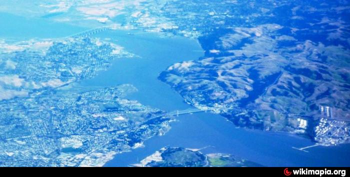
San Pablo Bay is a shallow tidal estuary that forms the northern extension of San Francisco Bay in northern California in the United States. It receives the waters of the Sacramento and San Joaquin rivers, via Suisun Bay and the Carquinez Strait on its east end, and it connects to San Francisco Bay on its south end.
Wikipedia article: http://en.wikipedia.org/wiki/San_Pablo_Bay
Nearby cities:
Coordinates: 38°2'52"N 122°22'48"W
- San Francisco Bay 15 km
- Monterey Bay 122 km
- Gulf of California 1115 km
- Sebastián Vizcaíno Bay 1299 km
- Banderas Bay 2505 km
- Matagorda Bay 2608 km
- Galveston Bay 2681 km
- West Bay/Western Galveston Bay 2686 km
- Gulf of Mexico 3268 km
- Golfo de Tehuantepec 3590 km
- Point Pinole Regional Shoreline 5.9 km
- China Camp State Park 10 km
- Wetlands Restoration 11 km
- Island Number One 11 km
- Bel Marin Keys, California 12 km
- Hamilton Army Airfield Site 12 km
- Las Galinas, California 13 km
- Santa Venetia, California 13 km
- Ignacio, California 14 km
- Black Point 14 km