Colonial Michilimackinac State Park (Mackinaw City, Michigan)
USA /
Michigan /
Mackinaw City /
Mackinaw City, Michigan
World
/ USA
/ Michigan
/ Mackinaw City
World / United States / Michigan
Michigan state park
Add category
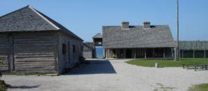

Fort Michilimackinac was an 18th century French, and later British, fort and trading post in the Great Lakes of North America. Built around 1715, it was located along the southern shore of the strategic Straits of Mackinac connecting Lake Huron and Lake Michigan, at the northern tip of the lower peninsula of the present-day state of Michigan in the United States. The site of the fort in present-day Mackinaw City is a National Historic Landmark and is now preserved as an open-air historical museum.
www.mackinacparks.com/parks/colonial-michilimackinac_7/
www.mackinacparks.com/parks/colonial-michilimackinac_7/
Wikipedia article: http://en.wikipedia.org/wiki/Fort_Michilimackinac
Nearby cities:
Coordinates: 45°47'11"N 84°43'55"W
- Wilderness State Park 22 km
- Fisherman's Island State Park 74 km
- Thompson's Harbor State Park 97 km
- Tahquamenon Falls State Park 108 km
- Hartwick Pines State Park 113 km
- Craig Lake State Park 284 km
- Ortonville Recreation Area 335 km
- Highland State Recreation Area 359 km
- Pinckney State Recreation Area 373 km
- Porcupine Mountains Wilderness State Park 420 km
- Lake Paradise 11 km
- Mackinac Island 12 km
- Bois Blanc Island 20 km
- Big St. Martin Island 22 km
- St. Martin Islands 22 km
- Douglas Lake 23 km
- Pellston Regional Airport (PLN/KPLN) 25 km
- Brevort Lake 28 km
- Marquette Island 33 km
- Hiawatha National Forest (Eastside) 44 km