Centre (region)
France /
Centre /
Crouy-sur-Cosson /
World
/ France
/ Centre
/ Crouy-sur-Cosson
France / World / Centre / Loir-et-Cher / Blois / Bracieux
region, invisible, first-level administrative division, draw only border
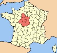

The administrative Region of Centre lies in the Paris Basin and covers much of north central and central France, including the central part of the Loire Valley. Its capital is Orléans.
The Centre Region is composed of six départements: Eure-et-Loire is its most northern département; Loiret is in the northeast corner of the region; Cher is positioned in the region’s southeast corner; Indre is in the south; Indre-et-Loire is in the southwest and Loir-et-Cher is in the northwest, between Loiret and Indre-et-Loire. The region’s capital is Orléans, which is about 75 miles south of Paris.
The Centre Region is composed of six départements: Eure-et-Loire is its most northern département; Loiret is in the northeast corner of the region; Cher is positioned in the region’s southeast corner; Indre is in the south; Indre-et-Loire is in the southwest and Loir-et-Cher is in the northwest, between Loiret and Indre-et-Loire. The region’s capital is Orléans, which is about 75 miles south of Paris.
Wikipedia article: http://en.wikipedia.org/wiki/Centre_(France)
Nearby cities:
Coordinates: 47°38'36"N 1°35'22"E
- Limousin 151 km
- Rhône-Alpes 203 km
- Jura Mountains 280 km
- Provence-Alpes-Côte d'Azur 346 km
- Piedmont 407 km
- Alsace 420 km
- Upper Rhine Graben 485 km
- Catalonia 544 km
- Emilia-Romagna 648 km
- Tuscany 718 km
- Château de Chambord 6.2 km
- Substation 7.6 km
- Saint-Laurent Nuclear Power Plant 8.6 km
- Château d'Avaray 8.9 km
- Railway traction substation 11 km
- Château d'Herbault 11 km
- Golf des Bordes 12 km
- Château de Menars 13 km
- BMX track Mont-Près-chambord 14 km
- Vineuil 16 km
Comments