Vrelo Bosne (Sarajevo)
Bosnia and Herzegovina /
Federacija Bosna i Hercegovina /
Hadzhici /
Sarajevo
World
/ Bosnia and Herzegovina
/ Federacija Bosna i Hercegovina
/ Hadzhici
World / Bosnia and Herzegovina / Federacija Bosna i Hercegovina / Sarajevo
park, spring

Vrelo Bosne is the name used for the source of the Bosna River, located about 15km southwest of the center of Sarajevo at the foot of the mountains, Igman and Bjelašnica. It is thought that the word Bosna comes from the word bosana, an old Indo-European word which means “water”.
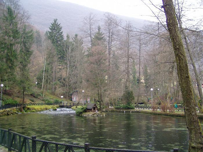
Vrelo Bosne has the status of a protected natural monument and covers an area of 603 hectares.
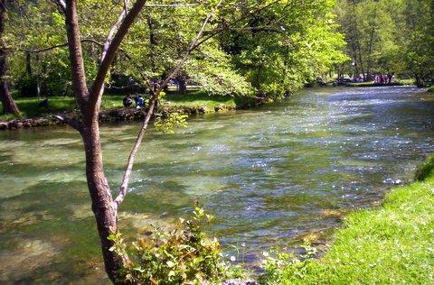
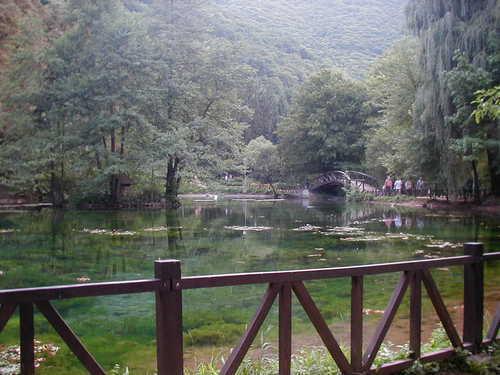
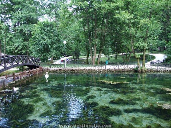
Water from six different sources flows through several pools and fish ponds and passes beneath small picturesque wooden bridges which are surrounded by lush vegetation and criss-crossed by walking paths.
Aquatic life mingles with the life on land, giving rise to a true botanical garden. Many species are found here, several of which are endemic to this area, and the white swans, which glide along the crystal clear ponds, are special attractions.
Vrelo Bosne is also an area which contains the main source for Sarajevo’s “Bačevo” drinking water.
Vrelo Bosne is well developed and maintained, with benches, sheltered places to rest and a playground, plus there is a restaurant in the center of the complex which serves a fine specialty – fresh river trout.
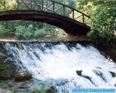
Downstream is the Bridge on the Pladište, known by locals as Rimski Most (Roman Bridge), a BiH national monument. Built during the Ottoman period, its name comes from the fact that pieces of old Roman buildings were used in its construction.
A walk through the chestnuts alley
The nicest way to reach Vrelo Bosne is along Velika Aleja, a wonderful 3.5 km-long lane for walking, lined with about 3,000 100-year-old chestnut and plane trees.
It can also be reached by taking a horse-drawn carriage along the Aleja. This form of transport has been in operation since 1895 and is one of Sarajevo’s most popular attractions.
There are luxurious villas along both sides of the Aleja which were built during the Austro-Hungarian period, providing members of high society with a place to rest in untouched nature.
It was the Austro-Hungarian administration which laid the foundations for Ilidža’s touristic attractions, such as Vrelo Bosne and Velika Aleja, as well as Stojčevac, Vrutci and the hotel and bath complex located at the other end of the Aleja.
While the healing properties of the sulfur waters in Ilidža were valued by the ancient Romans, as shown by the archeological sites near the sources of the thermal waters, Ilidža (the name for the Sarajevo municipality which comes from the Turkish word Iladž = medicine) really flourished during the Austro-Hungarian period.
Vrelo Bosne has the status of a protected natural monument and covers an area of 603 hectares.
Water from six different sources flows through several pools and fish ponds and passes beneath small picturesque wooden bridges which are surrounded by lush vegetation and criss-crossed by walking paths.
Aquatic life mingles with the life on land, giving rise to a true botanical garden. Many species are found here, several of which are endemic to this area, and the white swans, which glide along the crystal clear ponds, are special attractions.
Vrelo Bosne is also an area which contains the main source for Sarajevo’s “Bačevo” drinking water.
Vrelo Bosne is well developed and maintained, with benches, sheltered places to rest and a playground, plus there is a restaurant in the center of the complex which serves a fine specialty – fresh river trout.
Downstream is the Bridge on the Pladište, known by locals as Rimski Most (Roman Bridge), a BiH national monument. Built during the Ottoman period, its name comes from the fact that pieces of old Roman buildings were used in its construction.
A walk through the chestnuts alley
The nicest way to reach Vrelo Bosne is along Velika Aleja, a wonderful 3.5 km-long lane for walking, lined with about 3,000 100-year-old chestnut and plane trees.
It can also be reached by taking a horse-drawn carriage along the Aleja. This form of transport has been in operation since 1895 and is one of Sarajevo’s most popular attractions.
There are luxurious villas along both sides of the Aleja which were built during the Austro-Hungarian period, providing members of high society with a place to rest in untouched nature.
It was the Austro-Hungarian administration which laid the foundations for Ilidža’s touristic attractions, such as Vrelo Bosne and Velika Aleja, as well as Stojčevac, Vrutci and the hotel and bath complex located at the other end of the Aleja.
While the healing properties of the sulfur waters in Ilidža were valued by the ancient Romans, as shown by the archeological sites near the sources of the thermal waters, Ilidža (the name for the Sarajevo municipality which comes from the Turkish word Iladž = medicine) really flourished during the Austro-Hungarian period.
Wikipedia article: http://en.wikipedia.org/wiki/Vrelo_Bosne
Nearby cities:
Coordinates: 43°49'10"N 18°16'17"E
- Željeznica wellspring 21 km
- Bistrica river wellspring 27 km
- Vrelo Zlatac wellspring 53 km
- Vrelo Krupac, wellspring 56 km
- Bunica River Wellspring 73 km
- Krupa River Wellspring 129 km
- Springs of Ali Pasha 189 km
- Gurra e Kosodarit 273 km
- The springs of Ravenska river 300 km
- Vrutok 310 km
- Igman mountain 3.9 km
- Hadzici 5.1 km
- Garovci 5.5 km
- Kasatici 5.7 km
- Igman Ski - MALO POLJE 6.1 km
- Vojni Poligoni COO Pazarić 11 km
- Osenik 12 km
- luke 12 km
- Bjelašnica 19 km
- Trnovo (FB&H) 20 km
Comments