Nandoni Dam
| lake
South Africa /
Limpopo /
Thohoyandou /
World
/ South Africa
/ Limpopo
/ Thohoyandou
World / South Africa / Limpopo
lake, dam
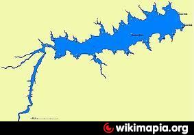
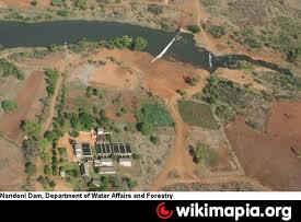
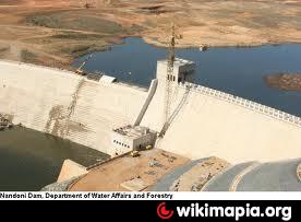
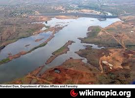
It is situated between Thohoyandou and Malamulele with a catchment area of 1 380km², which stretches from Makhado in the west to Malamulele in the east. The overall length of the dam wall is 2,215 kilometers with a spillway of 200 metres in length to accommodate the regional maximum flood of 4,650 cubic metres per second. The height of the dam wall is 47 meters. The dam was initially known as the Mutoti Dam, but the name was changed to Nandoni Dam in 1995.
Its main purpose is to supply water for domestic use. The areas and communities that benefit are the urban areas of Makhado and Thohoyandou and the rural communities in the northern part of the Limpopo. It has a net storage capacity of 164 million cubic metres.
Its main purpose is to supply water for domestic use. The areas and communities that benefit are the urban areas of Makhado and Thohoyandou and the rural communities in the northern part of the Limpopo. It has a net storage capacity of 164 million cubic metres.
Wikipedia article: http://en.wikipedia.org/wiki/Nandoni_dam
Nearby cities:
Coordinates: 22°59'19"S 30°33'17"E
- Massingir Dam 169 km
- Hayshope Reservoir 443 km
- Vaal Dam (man-made lake) 493 km
- Pongolapoort Dam 497 km
- Lake Sibhayi 518 km
- Sterkfontein Dam 621 km
- Woodstock Dam 647 km
- Bloemhof dam 710 km
- Katse Dam 712 km
- Lake Ihotry 1347 km
- phaphazela 8.6 km
- Maila 68 km
- Air Force Base Makhado 89 km
- Crater 100 km
- Possible Carbonatite 109 km
- ZJOBEHAYN MS 227 117 km
- Ha-SibalaMakgulu2 135 km
- Kruger National Park 140 km
- Ha-Sibalamakgulu 142 km
- Toporo 145 km
Comments