US Army Reserve Base Caven Point (Jersey City, New Jersey)
USA /
New Jersey /
Jersey City /
Jersey City, New Jersey /
Caven Point Road, 198
World
/ USA
/ New Jersey
/ Jersey City
World / United States / New Jersey
Second World War 1939-1945, military, police station, United States Army
198 Caven Point Rd.
Jersey City, NJ 07305
www.usar.army.mil/
USARB Caven Point sits on land originally part of Caven Point Army Depot. It is also used as police training site for Jersey City Police Department recruits.
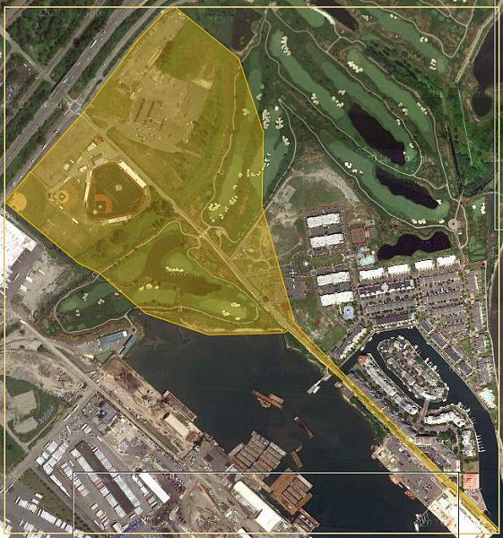
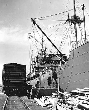
Operational from early 1900's until the early 1970's, the Caven Point Army Depot was a large US Army installation located on the tidal flats of Jersey City. During both World Wars, Caven Point's proximity to key rail networks and the ports of New York and New Jersey made it invaluable for the marshalling of troops, munitions and materials heading for front lines in Europe. A long pier allowed for loading of deep-draft ships.
During WWII, the facility was one of the major points of embarkation of US soldiers heading overseas, and was also one of the major East Coast POW processing points for captured German and Italian troops during the war. Following the cessation of hostilities, Caven Point was a key receiving point for homeward bound American servicemen, and again used its proximity to US rail lines to send tens of thousands of troops on their way home.
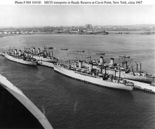
Following WWII, Caven Point became a dedicated troop facility, and its large finger pier became a storage point for US Army & Military Sea Transport Service troopships when they were not in active service. Caven Point was again called to action during both the Korean & Vietnam Wars, and also served as a transfer point for US personnel being returned stateside from foreign posts during the Cold War.
Budget cutbacks and the advancing age of the facility led to the Caven Point Army Depot to be drastically reduced in size during the late 1970's and the shoreside facilities were converted into a US Army Reserve Base which is still in operation today. The finger pier was eventually used as a breakwater to aid with the filling of much of the shallow mudflats that now make up Liberty State Park, and the outermost section of the pier is now used by the US Army Corps of Engineers as their New York Harbor headquarters.
Jersey City, NJ 07305
www.usar.army.mil/
USARB Caven Point sits on land originally part of Caven Point Army Depot. It is also used as police training site for Jersey City Police Department recruits.
Operational from early 1900's until the early 1970's, the Caven Point Army Depot was a large US Army installation located on the tidal flats of Jersey City. During both World Wars, Caven Point's proximity to key rail networks and the ports of New York and New Jersey made it invaluable for the marshalling of troops, munitions and materials heading for front lines in Europe. A long pier allowed for loading of deep-draft ships.
During WWII, the facility was one of the major points of embarkation of US soldiers heading overseas, and was also one of the major East Coast POW processing points for captured German and Italian troops during the war. Following the cessation of hostilities, Caven Point was a key receiving point for homeward bound American servicemen, and again used its proximity to US rail lines to send tens of thousands of troops on their way home.
Following WWII, Caven Point became a dedicated troop facility, and its large finger pier became a storage point for US Army & Military Sea Transport Service troopships when they were not in active service. Caven Point was again called to action during both the Korean & Vietnam Wars, and also served as a transfer point for US personnel being returned stateside from foreign posts during the Cold War.
Budget cutbacks and the advancing age of the facility led to the Caven Point Army Depot to be drastically reduced in size during the late 1970's and the shoreside facilities were converted into a US Army Reserve Base which is still in operation today. The finger pier was eventually used as a breakwater to aid with the filling of much of the shallow mudflats that now make up Liberty State Park, and the outermost section of the pier is now used by the US Army Corps of Engineers as their New York Harbor headquarters.
Wikipedia article: http://en.wikipedia.org/wiki/United_States_Army_Reserve
Nearby cities:
Coordinates: 40°41'36"N 74°4'45"W
- Floyd Bennett Field (NOP) 18 km
- Fort Hancock Historic Core 24 km
- NWS Earle Pier Complex/Leonardo Piers 26 km
- US Naval Weapons Station Earle 29 km
- Fort Monmouth Reuse and Redevelopment Area 41 km
- Munition Rail Transport Storage Area 47 km
- US Naval Weapons Station Earle - Mainside 47 km
- Naval Air Engineering Station - Lakehurst 78 km
- Naval Air Warfare Center (NAWC), Lakehurst, Aircraft Platform Interface Group 79 km
- Fort Dix Military Reservation 86 km
- Liberty National Golf Club 0.4 km
- Port Liberte Housing Development 0.7 km
- Greenville, Jersey City, NJ 1.5 km
- Our Lady of Mercy RC Parish 1.8 km
- Liberty State Park 2.6 km
- Upper New York Bay 3.1 km
- Paulus Hook, Jersey City, New Jersey 3.8 km
- CRRNJ Newark Branch (Partially Abandoned) 4.3 km
- Hudson County, New Jersey 4.4 km
- Brooklyn 13 km
Comments