Banks Peninsula
New Zealand /
Canterbury /
Akaroa /
World
/ New Zealand
/ Canterbury
/ Akaroa
World / New Zealand / Canterbury / Christchurch
peninsula, invisible
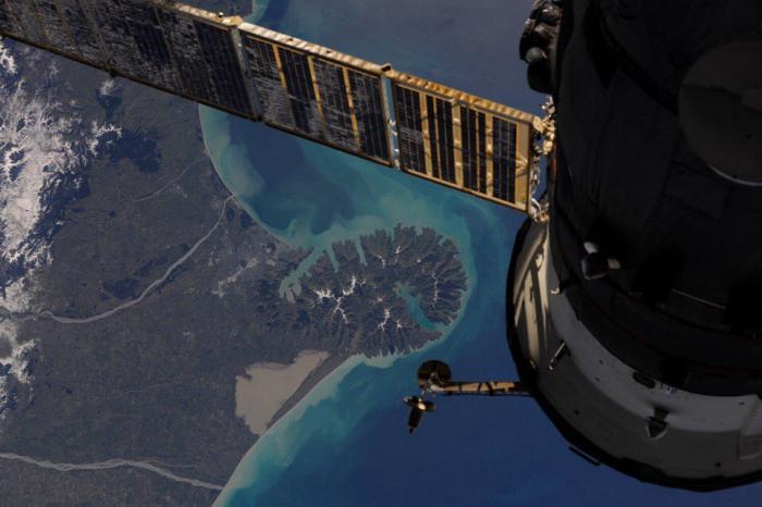
Banks Peninsula is in the Canterbury region on the east coast of the South Island of New Zealand, partly surrounded by the Pacific Ocean.
The peninsula has a land area of approximately 1,000 km². Banks Peninsula forms the most prominent volcanic feature of the South Island. Geologically, the peninsula comprises the eroded remnants of two large shield volcanoes.
When Captain Cook first mapped this area of New Zealand, he thought that it was an island. He named it after a naturalist on board the HMS Endeavour
Wikipedia article: http://en.wikipedia.org/wiki/Banks_Peninsula
Nearby cities:
Coordinates: 43°45'6"S 172°52'24"E
- Aupouri Peninsula 1042 km
- Mawson Peninsula 2958 km
- Adare Cape 3101 km
- Coffin Bay Peninsula 3391 km
- Dampier Peninsula 5642 km
- Bjerko Peninsula 6120 km
- Leihutu peninsula 6284 km
- Jeanne d'Arc Peninsula 7255 km
- Courbet Peninsula 7287 km
- Ampasindava 11574 km
- Akaroa Harbour 10 km
- Pigeon Bay 11 km
- Lake Wairewa/Forsyth 12 km
- Port Levy 14 km
- Lyttelton Harbour 17 km
- Birdlings Flat Beach 23 km
- Kaitorete Spit 28 km
- Te Waihora (Lake Ellesmere) 29 km
- Pegasus Bay 42 km
- IZONE - Rolleston Industrial Area 44 km