Union Church
| Episcopal Church, NRHP - National Register of Historic Places, interesting place, historic ruins
USA /
Virginia /
Falmouth /
World
/ USA
/ Virginia
/ Falmouth
church, Episcopal Church, NRHP - National Register of Historic Places, interesting place, historic ruins

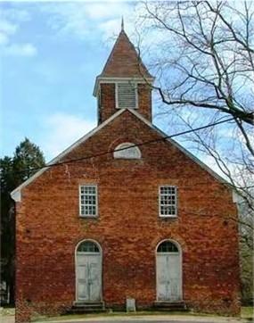

The Union Church of Falmouth, was used by four denominations: Presbyterian, Baptist, Methodist and Episcopalian. This particular building was the third church built on the site. It held its last service in 1935. By 1950 the building was in such disrepair that a storm caused the roof to collapse. Only the facade still stands.
The Falmouth Union Church was built in the 1820s on the foundation of an earlier church, which burned. As a "union church" it was used by Baptists, Methodists, Presbyterians, and Episcopalians on a rotating basis. It remained a focal point in the Falmouth community until storm damage occurred in the 1950s. Most of the structure was then torn down to salvage old bricks.
The Union Church is just a façade today, although a contributing structure to the Falmouth Historic District. There are no mandatory guidelines or landowner restrictions, however, governing the historic district. The church, an unfortunate victim, suffers from a number of structural maladies. Ruins of the belfry and cornice continue to rot or remain open to the elements. It is feared that the 2,000-pound bell–still in its belfry!– will fall and cause considerable damage. What exists of the east wall is precarious, especially at the base. Currently, iron rods are barely holding the structure together. Deteriorated asphalt shingles are lost with every strong gust of wind.
Although in disuse, Union Church continues to serve as a focal point, giving cultural identity to the historic town of Falmouth. It is a visual statement of the Town’s past and a reminder of the much-needed role of preservation in the community. The Church deserves salvation as a fine example of Federal architecture in a religious structure and as a survivor of war, storms, and salvage assaults.
A cemetery stands in the rear of the church. The oldest standing tombstone is dated 1738.
Wikipedia article: http://en.wikipedia.org/wiki/Union_Church_and_Cemetery
Nearby cities:
Coordinates: 38°19'20"N 77°28'2"W
- Fredericksburg Battlefield 3.9 km
- Battle of Chancellorsville 17 km
- Battle of Spotsylvania Courthouse 17 km
- Battle of the Wilderness 26 km
- Aerojet Propellant Lab 41 km
- Stratford Hall Plantation 56 km
- Manassas National Battlefield Park 59 km
- Blackwater National Wildlife Refuge 116 km
- Werowocomoco 121 km
- Battle of Hampton Roads 173 km
- St. Clair Brooks Park 0.5 km
- Falmouth, Virginia 1.4 km
- Chatham Plantation 1.8 km
- Downtown Fredericksburg 1.9 km
- National Historic District 2.4 km
- University of Mary Washington 2.5 km
- Grafton Village 3 km
- Bel Air 3.2 km
- Stafford County, Virginia 11 km
- Spotsylvania County, Virginia 22 km