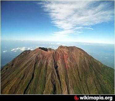
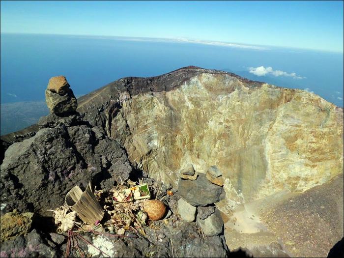
Mount Agung Crater
Indonesia /
Bali /
Karangasem /
World
/ Indonesia
/ Bali
/ Karangasem
World / Indonesia / Bali
mountain, volcano


Elevation: 3,031 m (9,944 ft)
Prominence: 3.031 m
Isolations: 105 kilometres (65 mi)
Type: Stratovolcano
Listing: Island high point / Ultra Ribu
Erupted: 1808, 1843, 1963-64, Sept 2017
Ranked 87th highest in the world (peaks by prominence)
Mount Agung or Gunung Agung is a mountain in Bali, Indonesia. This stratovolcano is the highest point on the island. It dominates the surrounding area, influencing the climate. The clouds come from the west and Agung takes their water so that the west is lush and green and the east dry and barren.
The Balinese believe that Mount Agung is a replica of Mount Meru, the central axis of the universe. One legend holds that the mountain is a fragment of Meru brought to Bali by the first Hindus. The most important temple on Bali, Pura Besakih, is located high on the slopes of Gunung Agung.[4]
Gunung Agung last erupted in 1963-1964 and is still active, with a large and very deep crater which occasionally belches smoke and ash. From a distance, the mountain appears to be perfectly conical, despite the existence of the large crater.
Wikipedia article: http://en.wikipedia.org/wiki/Mount_Agung
Nearby cities:
Coordinates: 8°20'35"S 115°30'25"E
- Giant Volcano - undersea Sumatra 1877 km
- Long Island 3496 km
- Newer Volcanics Province 4197 km
- Lake Taupo 6866 km
- Maroa Caldera 6877 km
- Volcano Pleiades 7874 km
- Chyulu Hills 8638 km
- Mount Kenya 8729 km
- Pilanesberg Alkaline Ring Complex 9482 km
- Bunyaruguru/Kichwambe Volcanic Field 9522 km
- Karangasem Regency 5.3 km
- Lake Batur 15 km
- Mt. Lempuyang 18 km
- Bangli Regency 18 km
- Tampaksiring 26 km
- Gianyar Regency 28 km
- Lombok Strait 45 km
- Bali 50 km
- Buleleng Regency 64 km
- Lombok 88 km
Comments