Amberd fortress
Armenia /
Aragatsotn /
Byurakan /
World
/ Armenia
/ Aragatsotn
/ Byurakan
ruins, interesting place
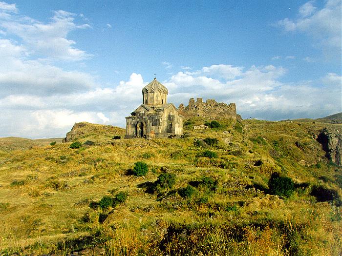
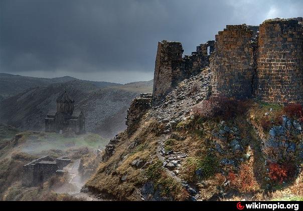

Amberd was a midcentury Armenian fort-city. It was built during the 10th century, 7km to the north of Byurakan village, of the historical Aragatzotn district (on the southern wing of the Aragats mountain). It was situated in the triangular cape where the rivers Arkashen and Amberd were joined, at an elevation of 2300m height.
The mansion and some parts of the fortress’s wall were constructed in the 7th century. In the 10th century it was the Amberdmilitary defense center of the Bagratuni and Pahlavuni kingdoms. Amberd lost its significance after the Tatar-Mongol invasions and was led to desolation by Lenktemur at the end of the 14th century.
The mansion and some parts of the fortress’s wall were constructed in the 7th century. In the 10th century it was the Amberdmilitary defense center of the Bagratuni and Pahlavuni kingdoms. Amberd lost its significance after the Tatar-Mongol invasions and was led to desolation by Lenktemur at the end of the 14th century.
Wikipedia article: http://en.wikipedia.org/wiki/Amberd
Nearby cities:
Coordinates: 40°23'15"N 44°13'42"E
- Dzoghkert / Menuakhinili 48 km
- Mren 51 km
- Old Bagaran 54 km
- Old Yervandashat 57 km
- Ruins of Ani 58 km
- Arshakavan 69 km
- Surb Hakob of Akori - Armenian monastery & cemetery 70 km
- Territory of Azerbaijan controlled by Armenia 88 km
- Ancient City of Ercis 176 km
- Adır (Lim) Island 185 km
- Voskevaz 13 km
- Arum (abandoned village) 18 km
- Aparan Community 19 km
- Metsamor Nuclear Power Plant 24 km
- Vagharshapat district 27 km
- Talin District 31 km
- Armavir District 33 km
- Ani region 43 km
- Baghramian District 44 km
- Ararat valley 49 km