Woodside VLF Transmitter
Australia /
Victoria /
Sale /
World
/ Australia
/ Victoria
/ Sale
World / Australia / Victoria
radiocommunication, VLF transmitter station

OMEGA was originally developed by the United States Navy for military aviation users. It was approved for development in 1968 with only eight transmitters and the ability to achieve a four mile accuracy when fixing a position. Each Omega station transmitted a very low frequency signal which consisted of a pattern of four tones unique to the station that was repeated every ten seconds. Because of this and radionavigation principles, an accurate fix of the receiver's position could be calculated. OMEGA employed hyperbolic radionavigation techniques and the chain operated in the VLF portion of the spectrum between 10 to 14 kHz. Near its end, it evolved into a system used primarily by the civil community. By receiving signals from three stations, an Omega receiver could locate a position to within 4 nautical miles using the principle of phase comparison of signals.
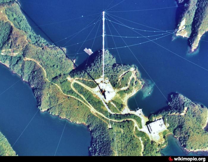
Omega stations used very extensive antennas in order to transmit their extremely low frequencies. They used grounded or insulated guyed masts with umbrella antennas, or wire-spans across fjords. Some Omega antennas were the tallest constructions on the continent where they stood or still stand.
When six of the eight station chain became operational in 1971, day to day operations were managed by the United States Coast Guard in partnership with Argentina, Norway, Liberia, and France. The Japanese and Australian stations became operational several years later. Coast Guard personnel operated two US stations: one in LaMoure, North Dakota and the other in Kaneohe, Hawaii on the island of Oahu.
Due to the success of the Global Positioning System the use of Omega declined during the 1990s, to a point where the cost of operating Omega could no longer be justified. Omega was permanently terminated on September 30, 1997 and all stations ceased operation.
Woodside Omega Transmitter (station G, now Woodside VLF transmitter) near Woodside, Victoria, Australia uses an umbrella antenna carried by a 432 metre high grounded lattice steel guyed mast. This mast is the highest construction in the southern hemisphere. After the shutdown of OMEGA it was used until 2004 as transmitter for orders to submarines on 13 kHz under the callsign VL3DEF. Today it works on 18.6 kHz.
Construction of this station was originally planned at New Zealand but after protests from anti-war protestors it was built in Australia.
Wikipedia article: http://en.wikipedia.org/wiki/OMEGA_Navigation_System
Nearby cities:
Coordinates: 38°28'52"S 146°56'6"E
- Ebino VLF transmitter (JJI) 8032 km
- Naval Radio Transmitter Facility Lualualei 8789 km
- Datong VLF Station 9383 km
- Prometey Russian Navy VLF station (RJH66) 11701 km
- “Ocean” Long Range Communications Center on Ultra-Low Frequencies of the Black Sea Fleet of the Russian Navy 14160 km
- Vlf Rsdn-20 14160 km
- Krasnodar RSDN-20 (Alpha) transmitter 14285 km
- Revda VLF (RSDN-20) - transmitter 14859 km
- Russian Navy's long-haul communications center 15286 km
- VLF transmitter DHO38 16549 km
- St Margaret Island 23 km
- Taara - Boolga National Park 32 km
- Loy Yang Power Complex 41 km
- Snake Island 45 km
- Little Snake Island 48 km
- Franklin Channel 52 km
- Hazelwood Pondage 53 km
- Toora Wind Farm 55 km
- Strzelecki Ranges 55 km
- Mirboo North Regional Park 60 km
Comments